File:Farallon nuclear waste dumping.png

Farallon_nuclear_waste_dumping.png (377 × 281 pixels, file size: 98 KB, MIME type: image/png)

Summary

Description
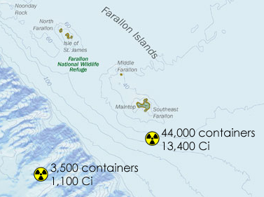
English: Modification of en:Image:Cordell Bank NMS map.jpg (created by NOAA) with general locations of nuclear waste dumping sites indicated. Over time many of the drums have moved and are not as isolated as these sites indicate; additionally it is potentially the case that some of the waste was never dropped at the exact locations to begin with.

According to a 1980 report by the Environmental Protection Agency, approximately 47,500 containers, 55 gallon steel drums, were dumped in the vicinity of the Farallones, with a total estimated radioactive activity of 14,500 Ci. All but 3,500 of these were dumped at 37º37'N, 123º17'W; the rest were dumped at 37º38'N, 123º08'W. These two locations are indicated on the map above.

Information on the dumping comes from: U.S. Environmental Protection Agency, Radioactive Waste Dumping Off the Coast of California, Fact Sheet (14 August 1980).

The little radioactive signs are from en:Image:Radiation warning symbol.svg, which is licensed as PD-self.
Source
Author

Licensing

Public domain
This image is in the public domain because it contains materials that originally came from the U.S. National Oceanic and Atmospheric Administration, taken or made as part of an employee's official duties.

العربية  čeština  Deutsch  Zazaki  English  español  eesti  suomi  français  hrvatski  magyar  italiano  日本語  한국어  македонски  മലയാളം  Plattdüütsch  Nederlands  polski  português  română  русский  sicilianu  slovenščina  Türkçe  Tiếng Việt  简体中文  繁體中文  +/−

Original upload log

The original description page was here. All following user names refer to en.wikipedia.
  • 2007-08-12 00:46 Panoptik 377×281× (99875 bytes) Modification of [[:Image:Cordell Bank NMS map.jpg]] (created by NOAA) with general locations of nuclear waste dumping sites indicated. Over time many of the drums have moved and are not as isolated as these sites indicate; additionally it is potentially t

Captions

Add a one-line explanation of what this file represents

Items portrayed in this file

depicts

File history

Click on a date/time to view the file as it appeared at that time.

Date/TimeThumbnailDimensionsUserComment
current18:56, 5 December 2008Thumbnail for version as of 18:56, 5 December 2008377 × 281 (98 KB)File Upload Bot (Magnus Manske) {{BotMoveToCommons|en.wikipedia}} {{Information |Description={{en|Modification of [[:en::Image:Cordell Bank NMS map.jpg]] (created by NOAA) with general locations of nuclear waste dumping sites indicated. Over time many of the drums have moved and are no

The following page uses this file:

Global file usage

The following other wikis use this file: