Size of this preview: 600 × 600 pixels. Other resolutions: 240 × 240 pixels | 480 × 480 pixels | 726 × 726 pixels.
Original file (726 × 726 pixels, file size: 95 KB, MIME type: image/png)
File history
Click on a date/time to view the file as it appeared at that time.
| Date/Time | Thumbnail | Dimensions | User | Comment | |
|---|---|---|---|---|---|
| current | 14:53, 27 April 2010 |  | 726 × 726 (95 KB) | Cogiati | added 17 april |
| 14:09, 26 April 2010 |  | 726 × 726 (93 KB) | Cogiati | added 18 april | |
| 07:32, 26 April 2010 |  | 726 × 726 (92 KB) | Cogiati | added 25 April | |
| 16:00, 25 April 2010 |  | 726 × 726 (91 KB) | Cogiati | added 16 april | |
| 01:56, 25 April 2010 |  | 726 × 726 (90 KB) | Cogiati | added 20 april | |
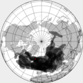
| 01:32, 25 April 2010 |  | 726 × 726 (88 KB) | Cogiati | {{Information |Description=This is a composite map showing the position of the Icelandinc volcanic ash cloud that closed European air space in different days. Based on maps found at http://www.metoffice.gov.uk/aviation/vaac/vaacuk_vag.html Days included: |
File usage
The following 3 pages use this file:
Global file usage
The following other wikis use this file:
- Usage on ca.wiki.x.io
- Usage on da.wiki.x.io
- Usage on de.wiki.x.io
- Usage on es.wiki.x.io
- Usage on eu.wiki.x.io
- Usage on fi.wiki.x.io
- Usage on hu.wiki.x.io
- Usage on it.wiki.x.io
- Usage on ja.wiki.x.io
- Usage on pnb.wiki.x.io
- Usage on pt.wiki.x.io
- Usage on ru.wiki.x.io
- Usage on th.wiki.x.io
- Usage on ur.wiki.x.io
- Usage on vi.wiki.x.io
- Usage on zh.wiki.x.io