Size of this preview: 461 × 599 pixels. Other resolutions: 184 × 240 pixels | 369 × 480 pixels | 590 × 768 pixels | 1,102 × 1,433 pixels.
Original file (1,102 × 1,433 pixels, file size: 764 KB, MIME type: image/png)
| This is a file from the Wikimedia Commons. Information from its description page there is shown below. Commons is a freely licensed media file repository. You can help. |
Summary
| Description |
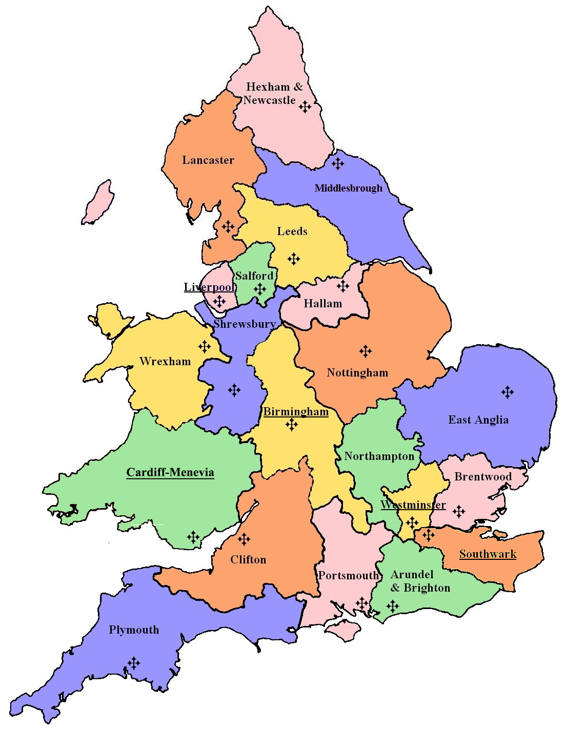
English: Map of the Roman Catholic Dioceses of England and Wales, including the Isle of Man, as of 2024. Names of archdioceses are underlined. |
| Date | |
| Source |
Own work This image includes elements that have been taken or adapted from this file: This image includes elements that have been taken or adapted from this file: |
| Author | DankJae |
| Permission (Reusing this file) |
This file is licensed under the Creative Commons Attribution-Share Alike 3.0 Unported license.
|
| Other versions |
|


File history
Click on a date/time to view the file as it appeared at that time.
| Date/Time | Thumbnail | Dimensions | User | Comment | |
|---|---|---|---|---|---|
| current | 18:59, 17 October 2024 | | 1,102 × 1,433 (764 KB) | DankJae | Uploaded own work with UploadWizard |
File usage
The following 38 pages use this file:
- Bishop of Wrexham
- Bishopric of the Forces in Great Britain
- Catholic Bishops' Conference of England and Wales
- Catholic Church in England and Wales
- List of Catholic churches in the United Kingdom
- List of Catholic dioceses (structured view)
- List of Catholic dioceses in Great Britain
- Personal Ordinariate of Our Lady of Walsingham
- Roman Catholic Archdiocese of Birmingham
- Roman Catholic Archdiocese of Cardiff-Menevia
- Roman Catholic Archdiocese of Liverpool
- Roman Catholic Archdiocese of Southwark
- Roman Catholic Diocese of Arundel and Brighton
- Roman Catholic Diocese of Brentwood
- Roman Catholic Diocese of Clifton
- Roman Catholic Diocese of East Anglia
- Roman Catholic Diocese of Hallam
- Roman Catholic Diocese of Hexham and Newcastle
- Roman Catholic Diocese of Lancaster
- Roman Catholic Diocese of Leeds
- Roman Catholic Diocese of Menevia
- Roman Catholic Diocese of Middlesbrough
- Roman Catholic Diocese of Newport and Menevia
- Roman Catholic Diocese of Northampton
- Roman Catholic Diocese of Nottingham
- Roman Catholic Diocese of Plymouth
- Roman Catholic Diocese of Portsmouth
- Roman Catholic Diocese of Salford
- Roman Catholic Diocese of Shrewsbury
- Roman Catholic Diocese of Westminster
- Roman Catholic Diocese of Wrexham
- Shropshire & Wrekin Catholic Region
- Syro-Malabar Catholic Eparchy of Great Britain
- Ukrainian Catholic Eparchy of the Holy Family of London
- Universalis Ecclesiae
- Talk:Roman Catholic dioceses in Great Britain
- Template:Catholic dioceses in England and Wales
- Category:Roman Catholic dioceses in England and Wales