No higher resolution available.
Elevation_map_of_Europe.jpg (500 × 500 pixels, file size: 27 KB, MIME type: image/jpeg)
| This is a file from the Wikimedia Commons. Information from its description page there is shown below. Commons is a freely licensed media file repository. You can help. |
Summary
| Description |
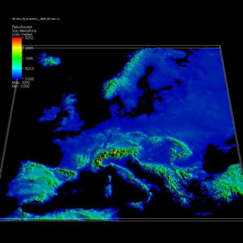
English: Elevation map of Europe
The featured plot shows an elevation map of Europe produced from a rectilinear NetCDF dataset in which cells at sea level have been removed. Data courtesy of Peter Goldstein Ph.D., LLNL. |
| Date | Updated: November 8, 2007 |
| Source | Visualizations that have been created with VisIt. at wci.llnl.gov |
| Author | Peter Goldstein Ph.D., LLNL. |
Licensing
This work is in the public domain in the United States because it is a work prepared by an officer or employee of the United States Government as part of that person’s official duties under the terms of Title 17, Chapter 1, Section 105 of the US Code.
Note: This only applies to original works of the Federal Government and not to the work of any individual U.S. state, territory, commonwealth, county, municipality, or any other subdivision. This template also does not apply to postage stamp designs published by the United States Postal Service since 1978. (See § 313.6(C)(1) of Compendium of U.S. Copyright Office Practices). It also does not apply to certain US coins; see The US Mint Terms of Use.
|
 | |
| This file has been identified as being free of known restrictions under copyright law, including all related and neighboring rights. | ||
File history
Click on a date/time to view the file as it appeared at that time.
| Date/Time | Thumbnail | Dimensions | User | Comment | |
|---|---|---|---|---|---|
| current | 22:12, 10 July 2008 | | 500 × 500 (27 KB) | Mdd | {{Information |Description={{en|1=Elevation map of Europe The featured plot shows an elevation map of Europe produced from a rectilinear NetCDF dataset in which cells at sea level have been removed. Data courtesy of Peter Goldstein Ph.D., LLNL. }} |Sou |
File usage
No pages on the English Wikipedia use this file (pages on other projects are not listed).