Size of this preview: 638 × 600 pixels. Other resolutions: 255 × 240 pixels | 511 × 480 pixels | 817 × 768 pixels | 1,089 × 1,024 pixels | 1,507 × 1,417 pixels.
Original file (1,507 × 1,417 pixels, file size: 350 KB, MIME type: image/png)
File history
Click on a date/time to view the file as it appeared at that time.
| Date/Time | Thumbnail | Dimensions | User | Comment | |
|---|---|---|---|---|---|
| current | 11:35, 23 October 2009 |  | 1,507 × 1,417 (350 KB) | Jonathan Oldenbuck | More accurate alignments of walls, better hatch on loch, white instead of transparent |
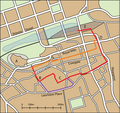
| 15:36, 19 October 2009 |  | 1,607 × 1,540 (334 KB) | Jonathan Oldenbuck | {{Information |Description=A map of central Edinburgh, showing the locations of the town walls, overlaid on the present day street pattern. Note not all streets are shown. Key: *A: Edinburgh Castle *B: Flodden Tower *C: Greyfriars Kirkyard *D: Netherbow |
File usage
The following page uses this file:
Global file usage
The following other wikis use this file:
- Usage on www.wikidata.org
