No higher resolution available.
Dutch_Gold_Coast_after_the_Anglo-Dutch_forts_trade_(1867).jpg (640 × 453 pixels, file size: 76 KB, MIME type: image/jpeg)
| This is a file from the Wikimedia Commons. Information from its description page there is shown below. Commons is a freely licensed media file repository. You can help. |

|
This historical map image could be re-created using vector graphics as an SVG file. This has several advantages; see Commons:Media for cleanup for more information. If an SVG form of this image is available, please upload it and afterwards replace this template with
{{vector version available|new image name}}.
It is recommended to name the SVG file “Dutch Gold Coast after the Anglo-Dutch forts trade (1867).svg”—then the template Vector version available (or Vva) does not need the new image name parameter. |


.jpg)
.jpg&action=edit&redlink=1)
.jpg)
Summary
| Description |
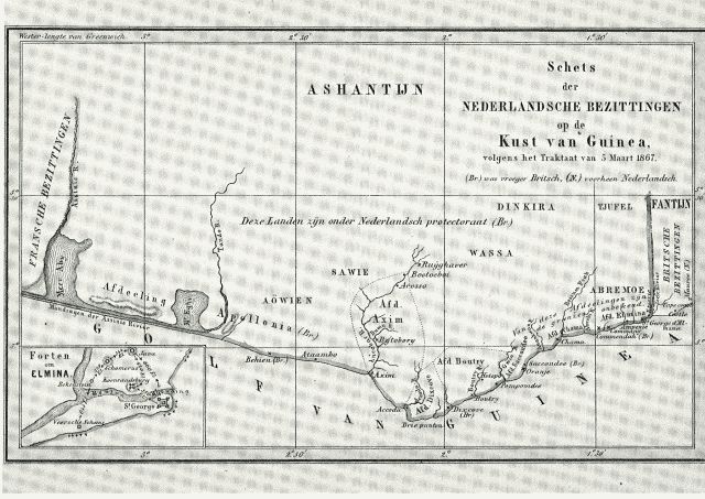
Nederlands: "Schets der Nederlandsche bezittingen op de Kust van Guinea volgen het Traktaat van 5 Maart 1867."
(Br.) was vroeger Brits, (N.) voorheen Nederlands
English: This map shows the Dutch possessions on the Gold Coast after forts were traded with Britain in 1867. All forts to the east of Elmina were given to Britain, those West of Elmina became Dutch. The treaty established a Dutch protectorate in the Gold Coast, but did not last long, as in 1872 all remaining Dutch forts were sold to the United Kingdom. |
| Date | |
| Source | http://www.engelfriet.net/Alie/Aad/elmina.htm |
| Author | Unknown author |
Licensing
|
This work is in the public domain in its country of origin and other countries and areas where the copyright term is the author's life plus 70 years or fewer. | |
| This file has been identified as being free of known restrictions under copyright law, including all related and neighboring rights. | |
File history
Click on a date/time to view the file as it appeared at that time.
| Date/Time | Thumbnail | Dimensions | User | Comment | |
|---|---|---|---|---|---|
| current | 17:12, 30 January 2011 | | 640 × 453 (76 KB) | Fentener van Vlissingen | {{Information |Description ={{nl|1="Schets der Nederlandsche bezittingen op de Kust van Guinea volgen het Traktaat van 5 Maart 1867." ''(Br.) was vroeger Brits, (N.) voorheen Nederlands'' }} {{en|1=This map shows the Dutch possessions on the Gold Coas |
File usage
The following pages on the English Wikipedia use this file (pages on other projects are not listed):
Global file usage
The following other wikis use this file:
- Usage on de.wiki.x.io
- Usage on fr.wiki.x.io
- Usage on it.wiki.x.io
- Usage on sl.wiki.x.io
- Usage on www.wikidata.org
.jpg)