Diu_Map.gif (487 × 406 pixels, file size: 7 KB, MIME type: image/gif)
Summary
edit| Description |
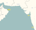
Map showing various Portuguese Indian Ocean domains around the early 16th century. |
|---|---|
| Source |
Diagram/Map created by uploader. |
| Date | |
| Author | |
| Permission (Reusing this file) |
See below.
|
| This image needs to be converted to the SVG format. Once that is done, it should be moved to Wikimedia Commons in accordance with Wikipedia's image policy. Once the image is improved, see moving files to Commons for information on how to proceed. If you can not convert to SVG, go ahead and move to the Commons anyway. See Move-to-commons assistant. |
Licensing
edit| I, the copyright holder of this work, hereby release it into the public domain. This applies worldwide. If this is not legally possible: |
File history
Click on a date/time to view the file as it appeared at that time.
| Date/Time | Thumbnail | Dimensions | User | Comment | |
|---|---|---|---|---|---|
| current | 17:43, 19 October 2005 |  | 487 × 406 (7 KB) | Mkamat (talk | contribs) | Early 16th century Portuguese possessions in the Indian Ocean. |
| 16:53, 19 October 2005 |  | 487 × 406 (7 KB) | Mkamat (talk | contribs) | Map showing various Portuguese Indian Ocean domains around the early 16th century. |
You cannot overwrite this file.
File usage
The following 3 pages use this file:
