Size of this preview: 538 × 600 pixels. Other resolutions: 215 × 240 pixels | 431 × 480 pixels | 689 × 768 pixels | 919 × 1,024 pixels | 2,154 × 2,401 pixels.
Original file (2,154 × 2,401 pixels, file size: 553 KB, MIME type: image/jpeg)
| This is a file from the Wikimedia Commons. Information from its description page there is shown below. Commons is a freely licensed media file repository. You can help. |
| Description |
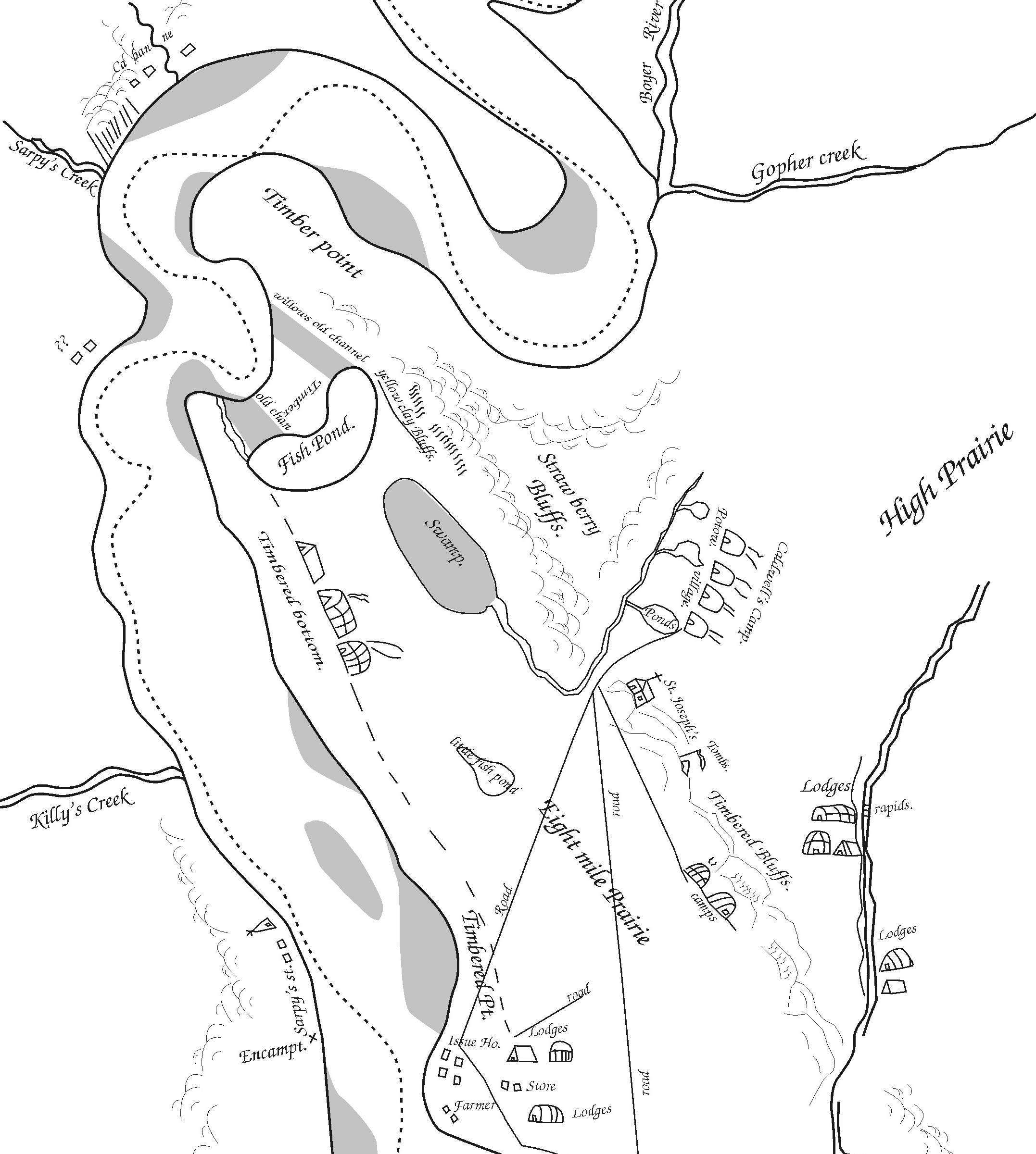
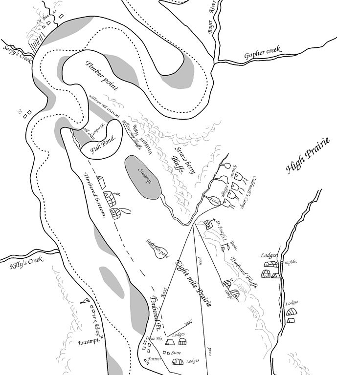
English: A small portion of Pierre-Jean De Smet's 1839 map of the Council Bluffs Region, traced by the contributor. The area labeled "Caldwell's Camp" was probably near or just southeast of Broadway, the "Fish Pond" is Big Lake Park, and "St. Joseph's" was the Council Bluffs blockhouse. |
| Date | 1839, 2008 |
| Source | The original maps are on file in St. Louis, copies of this map have been widely published. See Journal of the Iowa Archeological Society Vol. 55 (2008) for more info. |
| Author | Billwhittaker (talk) 18:28, 8 December 2008 (UTC) |

|
This old map image could be re-created using vector graphics as an SVG file. This has several advantages; see Commons:Media for cleanup for more information. If an SVG form of this image is available, please upload it and afterwards replace this template with
{{vector version available|new image name}}.
It is recommended to name the SVG file “De Smet Council Bluffs.svg”—then the template Vector version available (or Vva) does not need the new image name parameter. |


Licensing
|
This work is in the public domain in its country of origin and other countries and areas where the copyright term is the author's life plus 70 years or fewer. | |
| This file has been identified as being free of known restrictions under copyright law, including all related and neighboring rights. | |
Original upload log
Transferred from en.wikipedia to Commons by Sfan00_IMG using CommonsHelper.
The original description page was here. All following user names refer to en.wikipedia.
- 2008-12-08 18:28 Billwhittaker 2154×2401× (566607 bytes) {{Information |Description=A small portion of Pierre-Jean De Smet's 1839 map of the Council Bluffs Region, traced by the contributor. The area labeled "Caldwell's Camp" was probably near or just southeast of Broadway, the "Fish Pond" is Big Lake Park, and
File history
Click on a date/time to view the file as it appeared at that time.
| Date/Time | Thumbnail | Dimensions | User | Comment | |
|---|---|---|---|---|---|
| current | 15:12, 14 April 2009 | | 2,154 × 2,401 (553 KB) | File Upload Bot (Magnus Manske) | {{BotMoveToCommons|en.wikipedia|year={{subst:CURRENTYEAR}}|month={{subst:CURRENTMONTHNAME}}|day={{subst:CURRENTDAY}}}} {{Information |Description={{en|A small portion of Pierre-Jean De Smet's 1839 map of the Council Bluffs Region, traced by the contribut |
File usage
The following pages on the English Wikipedia use this file (pages on other projects are not listed):
Global file usage
The following other wikis use this file:
- Usage on de.wiki.x.io
- Usage on es.wiki.x.io
- Usage on fr.wiki.x.io
- Usage on ja.wiki.x.io
- Usage on no.wiki.x.io
- Usage on pt.wiki.x.io