
Size of this preview: 484 × 600 pixels. Other resolutions: 194 × 240 pixels | 540 × 669 pixels.
Original file (540 × 669 pixels, file size: 118 KB, MIME type: image/jpeg)
| This is a file from the Wikimedia Commons. Information from its description page there is shown below. Commons is a freely licensed media file repository. You can help. |
Summary
| Description |
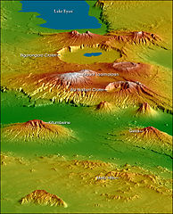
English: Topographical map of the w:Crater Highlands in Tanzania. Color indicates height, with lowest elevations in green and highest elevations in white. Shading shows the slope. The vertical relief has been exaggerated by a factor of 2 to reveal greater detail about the landscape. The image is oriented as though you were looking from the north toward the southwest.
Afrikaans: Topografiese kaart van Tanzanië se kraterhooglande. Kleur dui hoogte aan, met laagste gebiede in groen en hoogste hoogtes in wit. Skadu dui hellings aan, en die vertikale reliëf is verdubbel om meer landskapdetail weer te gee. Die uitsig is georiënteer van die noordooste na suidweste. Natronmeer is net buite sig aan regterhand. |
| Date | |
| Source | https://earthobservatory.nasa.gov/IOTD/view.php?id=6316 |
| Author | Robert E. Crippen, NASA/JPL Shuttle Radar Topography Mission team. Labels by NASA Earth Observatory newsroom. |
| Permission (Reusing this file) |
US government, public domain. |
| Other versions |
Derivative works of this file: CraterHighlands Tanzania NASA unannotated.jpg Larger, unannotated version available at source URL. |
Licensing
| This file is in the public domain in the United States because it was solely created by NASA. NASA copyright policy states that "NASA material is not protected by copyright unless noted". (See Template:PD-USGov, NASA copyright policy page or JPL Image Use Policy.) | ||
 |
Warnings:
|
File history
Click on a date/time to view the file as it appeared at that time.
| Date/Time | Thumbnail | Dimensions | User | Comment | |
|---|---|---|---|---|---|
| current | 17:53, 28 April 2006 | | 540 × 669 (118 KB) | Holly Cheng | {{Information | Description=Topographical map of the w:Crater Highlands in Tanzania. Color indicates height, with lowest elevations in green and highest elevations in white. Shading shows the slope. The vertical relief has been exaggerated by a factor |
File usage
The following pages on the English Wikipedia use this file (pages on other projects are not listed):
Global file usage
The following other wikis use this file:
- Usage on arz.wiki.x.io
- Usage on avk.wiki.x.io
- Usage on ceb.wiki.x.io
- Usage on de.wiki.x.io
- Usage on el.wiki.x.io
- Usage on es.wiki.x.io
- Usage on fr.wiki.x.io
- Usage on he.wiki.x.io
- Usage on hr.wiki.x.io
- Usage on ru.wiki.x.io
- Usage on sh.wiki.x.io
- Usage on sl.wiki.x.io
- Usage on sr.wiki.x.io
- Usage on sw.wiki.x.io
- Usage on uk.wiki.x.io
- Usage on www.wikidata.org
- Usage on zh.wiki.x.io