
Original file (923 × 1,155 pixels, file size: 448 KB, MIME type: image/jpeg)
| This is a file from the Wikimedia Commons. Information from its description page there is shown below. Commons is a freely licensed media file repository. You can help. |
Summary
| Description |
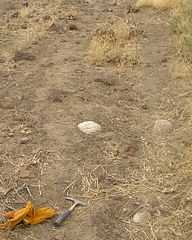
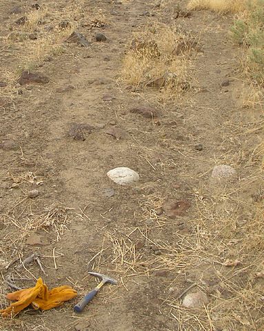
English: Glacial erraticsThe maximum elevation of the flood, as established by other indications, is confirmed by glacial erratics, which were stranded on the slopes of the en:Horse Heaven Hills and other elevated regions in the mid-Columbia at elevations of up to 1200 feet above sea level.[1] There were several long ridges (Saddle Mountains, Frenchman Hills, and Rattlesnake Mountain) that were above flood level. Peaks like the Badger, Candy, and Red Mountains were islands.[2][3][4] At this level, much of the en:Columbia Basin would have been submerged. This is a sample of erratics on Red Mountain. References
|
| Date | late September 2006 |
| Source | Own work |
| Author | Williamborg |
Licensing

|
Permission is granted to copy, distribute and/or modify this document under the terms of the GNU Free Documentation License, Version 1.2 or any later version published by the Free Software Foundation; with no Invariant Sections, no Front-Cover Texts, and no Back-Cover Texts. A copy of the license is included in the section entitled GNU Free Documentation License. |
| This file is licensed under the Creative Commons Attribution-Share Alike 3.0 Unported license. | ||
| ||
| This licensing tag was added to this file as part of the GFDL licensing update. |
File history
Click on a date/time to view the file as it appeared at that time.
| Date/Time | Thumbnail | Dimensions | User | Comment | |
|---|---|---|---|---|---|
| current | 00:25, 2 October 2006 | | 923 × 1,155 (448 KB) | Williamborg | ===Glacial erratics=== {{main|Glacial erratic}} The maximum elevation of the flood, as established by other indications, is confirmed by glacial erratics, which were stranded on the slopes of the Horse Heaven Hills and other elevated regions in th |
File usage
The following 2 pages use this file: