No higher resolution available.
China_1936.png (120 × 131 pixels, file size: 13 KB, MIME type: image/png)
| This is a file from the Wikimedia Commons. Information from its description page there is shown below. Commons is a freely licensed media file repository. You can help. |
Summary
| Description |
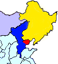
English: This map shows the territory controlled by the Hebei-Chahar Political Council (blue), the East Hebei Anti-Communist Autonomous Government (red), Manchukuo (yellow), and Mongolia (grey) at the end of 1935 and the beginning of 1936. As noted on Wikipedia, the Hebei-Chahar Political Council controlled the provinces of Chahar and Hebei except for the portion of Hebei Province occuped by the East Hebei Anti-Communist Autonomous Government, which, as noted by Paul French in The Old Shanghai A-Z and other sources, controlled the 22 northeastern counties of Hebei Province running along the Great Wall and south into the demilitarized zone almost as far south as Beijing and Tianjin.
Although this is a crude map based off "File:ROC-Chahar.png", there are several articles in severe need of some sort of geographic illustration, |
| Date | |
| Source | Own work |
| Author | CurtisNaito |
Licensing
I, the copyright holder of this work, hereby publish it under the following license:
This file is licensed under the Creative Commons Attribution-Share Alike 3.0 Unported license.
- You are free:
- to share – to copy, distribute and transmit the work
- to remix – to adapt the work
- Under the following conditions:
- attribution – You must give appropriate credit, provide a link to the license, and indicate if changes were made. You may do so in any reasonable manner, but not in any way that suggests the licensor endorses you or your use.
- share alike – If you remix, transform, or build upon the material, you must distribute your contributions under the same or compatible license as the original.
File history
Click on a date/time to view the file as it appeared at that time.
| Date/Time | Thumbnail | Dimensions | User | Comment | |
|---|---|---|---|---|---|
| current | 23:27, 18 October 2012 | | 120 × 131 (13 KB) | CurtisNaito | User created page with UploadWizard |
File usage
The following 2 pages use this file:
Global file usage
The following other wikis use this file:
- Usage on es.wiki.x.io
- Usage on ja.wiki.x.io
- Usage on ko.wiki.x.io
- Usage on nl.wiki.x.io
- Usage on uk.wiki.x.io
- Usage on www.wikidata.org
- Usage on zh.wiki.x.io