
Size of this PNG preview of this SVG file: 465 × 470 pixels. Other resolutions: 237 × 240 pixels | 475 × 480 pixels | 760 × 768 pixels | 1,013 × 1,024 pixels | 2,026 × 2,048 pixels.
Original file (SVG file, nominally 465 × 470 pixels, file size: 99 KB)
| This is a file from the Wikimedia Commons. Information from its description page there is shown below. Commons is a freely licensed media file repository. You can help. |
Summary
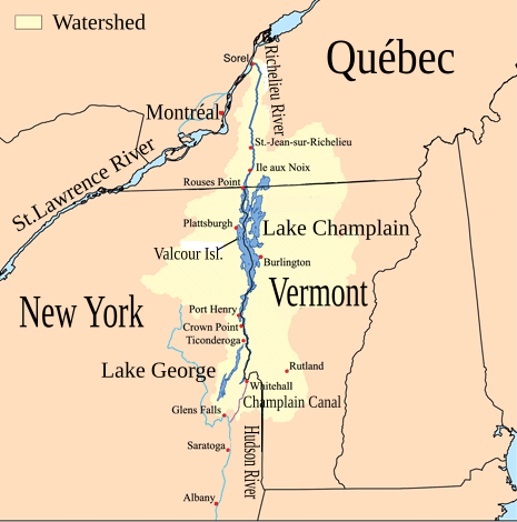
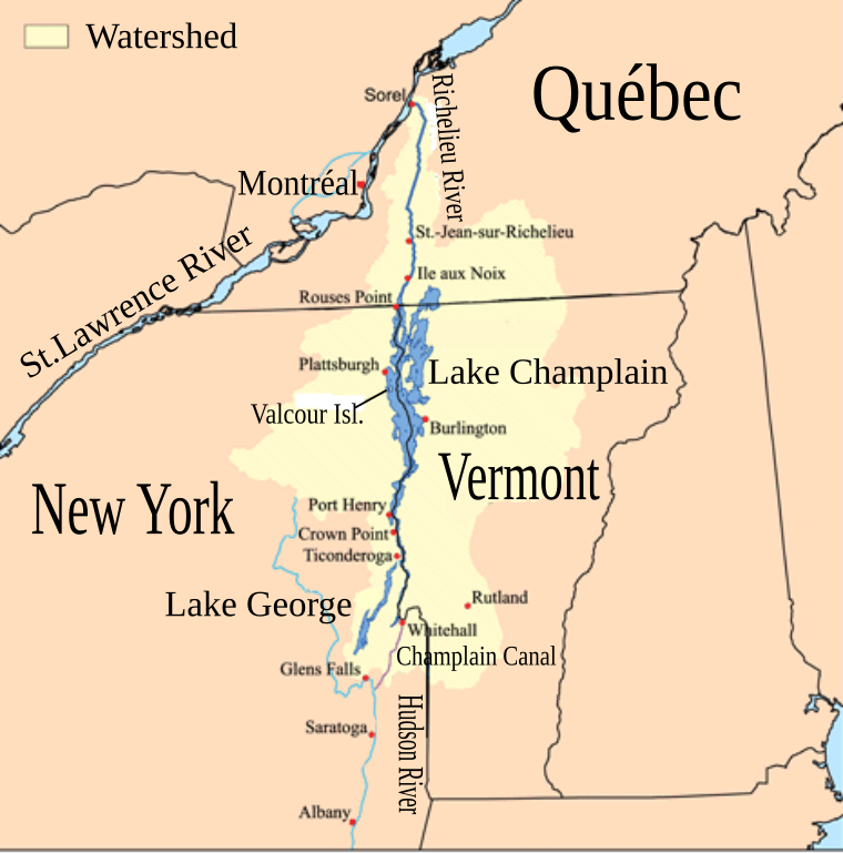
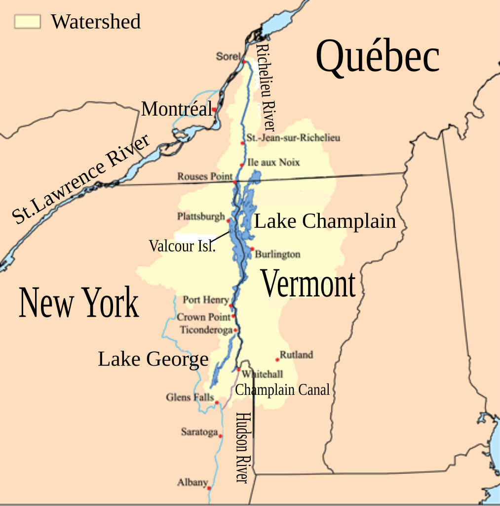
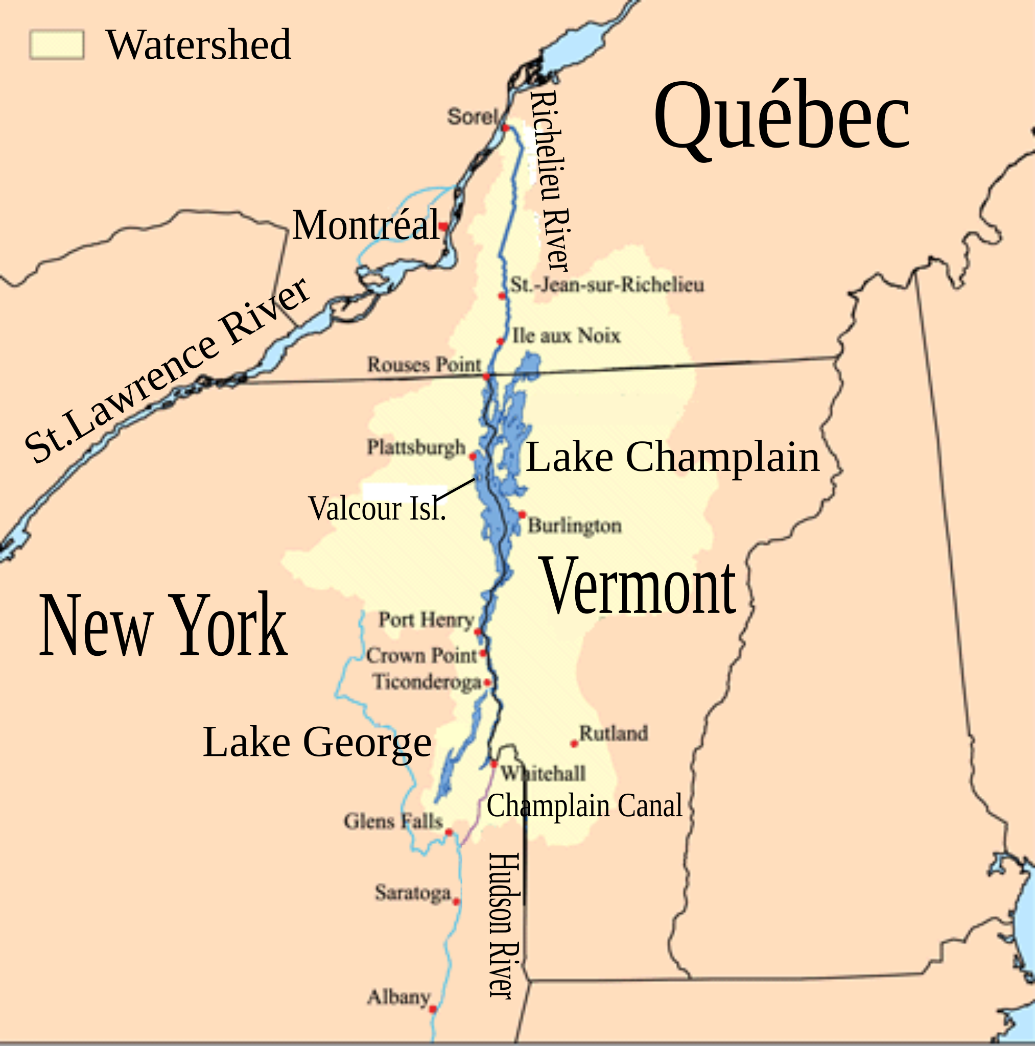
| Description | This is a map showing the Lake Champlain - Richelieu River watershed. I made using USGS, Census Bureau, and Digital Chart of the World data. | ||
| Date | |||
| Source | Champlainmap.png | ||
| Author |
|
||
| SVG development |
|

Licensing
I, the copyright holder of this work, hereby publish it under the following license:
This file is licensed under the Creative Commons Attribution-Share Alike 2.5 Generic license.
- You are free:
- to share – to copy, distribute and transmit the work
- to remix – to adapt the work
- Under the following conditions:
- attribution – You must give appropriate credit, provide a link to the license, and indicate if changes were made. You may do so in any reasonable manner, but not in any way that suggests the licensor endorses you or your use.
- share alike – If you remix, transform, or build upon the material, you must distribute your contributions under the same or compatible license as the original.
Original upload log
This image is a derivative work of the following images:
- Champlainmap.png licensed with Cc-by-sa-2.5
- 2011-03-28T23:38:51Z Gilbertus 465x470 (36608 Bytes) retrait du cadre
- 2006-07-26T17:29:43Z Kmusser 500x500 (34969 Bytes)
- 2006-07-26T17:02:12Z Kmusser 500x500 (34791 Bytes) This is a map showing the [[:en:Lake Champlain|Lake Champlain]] - [[:en:Richelieu River|Richelieu River]] watershed. I made using [[:en:United States Geological Survey|USGS]], [[:en:United States Census Bureau|Census Bureau]
Uploaded with derivativeFX
File history
Click on a date/time to view the file as it appeared at that time.
| Date/Time | Thumbnail | Dimensions | User | Comment | |
|---|---|---|---|---|---|
| current | 01:53, 26 December 2011 | | 465 × 470 (99 KB) | Pierre cb | Correcting typo and size of boxes |
| 01:13, 26 December 2011 |  | 465 × 470 (99 KB) | Pierre cb | == {{int:filedesc}} == {{Information |Description=This is a map showing the Lake Champlain - Richelieu River watershed. I made using USGS, [[:en:United States Census Bu |
File usage
The following pages on the English Wikipedia use this file (pages on other projects are not listed):
- 2011 Lake Champlain and Richelieu River floods
- Battle of Lake George
- Battle of Saint-Charles
- Battle of Saint-Denis (1837)
- Benjamin Ruggles Woodbridge
- Canadian canoe routes
- Champ (folklore)
- Lake Champlain Seaway
- List of rivers of New York
- List of rivers of Vermont
- Richelieu River
- USS Spitfire (1776 gunboat)
Global file usage
The following other wikis use this file:
- Usage on ar.wiki.x.io
- Usage on bg.wiki.x.io
- Usage on ca.wiki.x.io
- Usage on es.wiki.x.io
- Usage on fa.wiki.x.io
- Usage on hu.wiki.x.io
- Usage on it.wiki.x.io
- Usage on la.wiki.x.io
- Usage on lv.wiki.x.io
- Usage on mk.wiki.x.io
- Usage on pl.wiki.x.io
- Usage on pnb.wiki.x.io
- Usage on sr.wiki.x.io
- Usage on th.wiki.x.io
- Usage on xmf.wiki.x.io