Size of this preview: 680 × 599 pixels. Other resolutions: 272 × 240 pixels | 545 × 480 pixels | 872 × 768 pixels | 1,162 × 1,024 pixels | 1,280 × 1,128 pixels.
Original file (1,280 × 1,128 pixels, file size: 551 KB, MIME type: image/png)
File history
Click on a date/time to view the file as it appeared at that time.
| Date/Time | Thumbnail | Dimensions | User | Comment | |
|---|---|---|---|---|---|
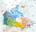
| current | 21:40, 16 April 2007 |  | 1,280 × 1,128 (551 KB) | Jurock | {{Information |Description=Geopolitical map of Canada |Source=[http://en.wiki.x.io/wiki/Image:Map_Canada_political%2Bgeo.png Wikipedia in English] |Date=11 March 2006 |Author=E Pluribus Anthony |Permission= |other_versions=No |
File usage
No pages on the English Wikipedia use this file (pages on other projects are not listed).
Global file usage
The following other wikis use this file:
- Usage on ast.wiki.x.io
- Usage on ca.wiki.x.io
- Usage on da.wiki.x.io
- Usage on es.wiki.x.io
- Usage on nn.wiki.x.io