
Size of this preview: 746 × 599 pixels. Other resolutions: 299 × 240 pixels | 598 × 480 pixels | 860 × 691 pixels.
Original file (860 × 691 pixels, file size: 199 KB, MIME type: image/png)
| This is a file from the Wikimedia Commons. Information from its description page there is shown below. Commons is a freely licensed media file repository. You can help. |
Summary
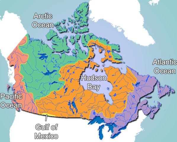
| Description | Canada drainage basins |
| Date | |
| Source | GIS Data |
| Author | Qyd (talk · contribs) |
| Permission (Reusing this file) |
All |
Licensing
| I, the copyright holder of this work, release this work into the public domain. This applies worldwide. In some countries this may not be legally possible; if so: I grant anyone the right to use this work for any purpose, without any conditions, unless such conditions are required by law. |
File history
Click on a date/time to view the file as it appeared at that time.
| Date/Time | Thumbnail | Dimensions | User | Comment | |
|---|---|---|---|---|---|
| current | 00:46, 23 November 2006 | | 860 × 691 (199 KB) | Qyd | fix '''Gulf''' of Mexico label, wash out oceans |
| 02:53, 22 November 2006 |  | 860 × 691 (190 KB) | Qyd | {{Information |Description=Canada Drainage basins |Source=GIS Data |Date=Nov 2006 |Author={{User|Qyd}} |Permission=All |other_versions= }} Category:Maps of Canada |
File usage
The following page uses this file:
Global file usage
The following other wikis use this file:
- Usage on ast.wiki.x.io
- Usage on bg.wiki.x.io
- Usage on ca.wiki.x.io
- Usage on ca.wikimedia.org
- Usage on da.wiki.x.io
- Usage on de.wiki.x.io
- Usage on es.wiki.x.io
- Usage on fr.wiki.x.io
- Usage on hu.wiki.x.io
- Usage on ja.wiki.x.io
- Usage on nl.wiki.x.io
- Usage on no.wiki.x.io
- Usage on ru.wiki.x.io
- Usage on sv.wiki.x.io
- Usage on uk.wiki.x.io