Size of this preview: 719 × 600 pixels. Other resolutions: 288 × 240 pixels | 576 × 480 pixels | 1,000 × 834 pixels.
Original file (1,000 × 834 pixels, file size: 185 KB, MIME type: image/jpeg)
| This is a file from the Wikimedia Commons. Information from its description page there is shown below. Commons is a freely licensed media file repository. You can help. |
Summary
| Description |
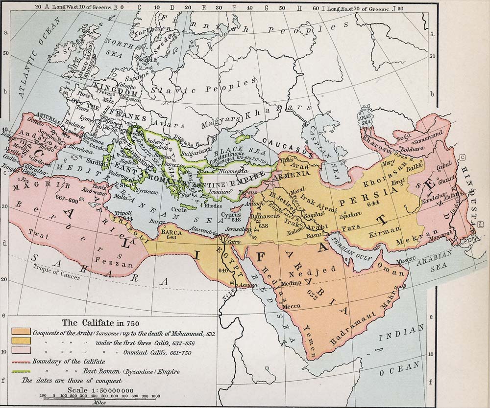
English: Map of the Umayyad Caliphate in 750 CE. |
| Date | map by William R. Shepherd (12 June 1871 – 7 June 1934). |
| Source | |
| Author | Sheperd, William R.; Historical Atlas; New York: Henry Holt and Company, 1911. 53. |
| Other versions |
[]
|


Licensing
This media file is in the public domain in the United States. This applies to U.S. works where the copyright has expired, often because its first publication occurred prior to January 1, 1929, and if not then due to lack of notice or renewal. See this page for further explanation.
|
 | |
 |
File history
Click on a date/time to view the file as it appeared at that time.
| Date/Time | Thumbnail | Dimensions | User | Comment | |
|---|---|---|---|---|---|
| current | 14:24, 2 May 2010 | | 1,000 × 834 (185 KB) | Feydey | {{Information |Description={{en|1=Map of the Caliphate in 750.}} |Source=* http://www.shadowedrealm.com/maps/political/view/the_caliphate * http://www.shadowedrealm.com/maps/political/ |Author=Sheperd, William R. Historical Atlas. New York: Henry Holt and |
File usage
The following 8 pages use this file:
Global file usage
The following other wikis use this file:
- Usage on af.wiki.x.io
- Usage on ca.wiki.x.io
- Usage on el.wiki.x.io
- Usage on es.wiki.x.io
- Usage on et.wiki.x.io
- Usage on eu.wiki.x.io
- Usage on fa.wiki.x.io
- Usage on hu.wiki.x.io
- Usage on hy.wiki.x.io
- Usage on id.wiki.x.io
- Usage on it.wiki.x.io
- Usage on ja.wiki.x.io
- Usage on ko.wiki.x.io
- Usage on nl.wiki.x.io
- Usage on pl.wiki.x.io
- Usage on pnb.wiki.x.io
- Usage on ru.wiki.x.io
- Usage on sl.wiki.x.io
- Usage on ur.wiki.x.io
- Usage on www.wikidata.org