.png)
.png&action=edit&redlink=1)
No higher resolution available.
Brazil_provinces_1889_new_(edit).png (435 × 369 pixels, file size: 12 KB, MIME type: image/png)
| This is a file from the Wikimedia Commons. Information from its description page there is shown below. Commons is a freely licensed media file repository. You can help. |
.png)
Summary
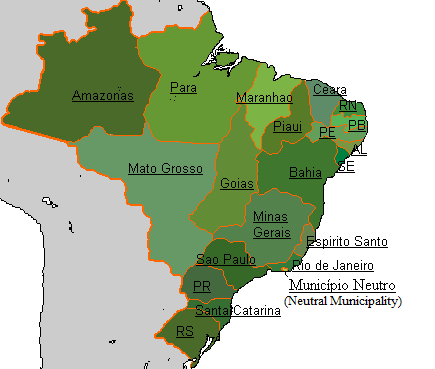
| Description | Map of the Empire of Brazil in 1889. |
| Date | 11 April 2012, 20:47 (UTC) |
| Source |
This file was derived from: Brazil provinces 1889 new.png: |
| Author |
|

|
File:Brazil Provinces 1889.svg is a vector version of this file. It should be used in place of this PNG file when not inferior.
File:Brazil provinces 1889 new (edit).png → File:Brazil Provinces 1889.svg
For more information, see Help:SVG. |
 |
| This is a retouched picture, which means that it has been digitally altered from its original version. Modifications: remove borders of other countries. The original can be viewed here: Brazil provinces 1889 new.png:
|
Licensing
I, the copyright holder of this work, hereby publish it under the following licenses:
| This file is licensed under the Creative Commons Attribution-Share Alike 3.0 Unported license. | ||
| ||
| This licensing tag was added to this file as part of the GFDL licensing update. |

|
Permission is granted to copy, distribute and/or modify this document under the terms of the GNU Free Documentation License, Version 1.2 or any later version published by the Free Software Foundation; with no Invariant Sections, no Front-Cover Texts, and no Back-Cover Texts. A copy of the license is included in the section entitled GNU Free Documentation License. |
You may select the license of your choice.
Original upload log
This image is a derivative work of the following images:
- File:Brazil_provinces_1889_new.png licensed with Cc-by-sa-3.0-migrated, GFDL, GFDL-user-w
- 2012-04-11T17:43:11Z Lecen 435x369 (21213 Bytes) Correction
- 2012-04-11T17:04:11Z Dcoetzee 435x369 (21197 Bytes) Reverted to version as of 02:18, 10 April 2012 - new versions should be uploaded under new filenames, where there is a dispute.
- 2012-04-10T02:47:57Z Pedro Aguiar 435x369 (21254 Bytes) Reverted to version as of 02:05, 10 April 2012; user Lecen is ignoring discussion, not presenting arguments and creating edit war
- 2012-04-10T02:18:42Z Lecen 435x369 (21197 Bytes) Reverted to version as of 12:07, 5 April 2012
- 2012-04-10T02:05:40Z Pedro Aguiar 435x369 (21254 Bytes) Reverted to version as of 23:51, 2 April 2012 - no vandalism; refer to discussion page for details
- 2012-04-05T12:07:24Z Lecen 435x369 (21197 Bytes) Reverted vandalism
- 2012-04-02T23:51:12Z Pedro Aguiar 435x369 (21254 Bytes) Corrected border inaccuracies
- 2010-12-16T00:06:50Z Lecen 435x369 (21197 Bytes) Improved.
- 2010-07-03T02:09:30Z Dcoetzee 435x369 (13994 Bytes) Remove watermark
- 2008-09-15T11:50:21Z Lecen 435x369 (15384 Bytes) {{Information |Description= Map of the Empire of Brazil in 1889. |Source= Wikipedia |Date=2008 |Author=Arab League |Permission= The author gave permission to copy, distribute and or/modify under the terms of the GNU Free Doc
Uploaded with derivativeFX
File history
Click on a date/time to view the file as it appeared at that time.
| Date/Time | Thumbnail | Dimensions | User | Comment | |
|---|---|---|---|---|---|
| current | 20:48, 11 April 2012 | | 435 × 369 (12 KB) | Jbarta | == {{int:filedesc}} == {{Information |Description=Map of the Empire of Brazil in 1889. |Source={{Derived from|Brazil_provinces_1889_new.png|display=50}} |Date=2012-04-11 20:47 (UTC) |Author=*File:Brazil_provinces_1889_new.png: Arab League *deriva... |
File usage
The following pages on the English Wikipedia use this file (pages on other projects are not listed):
.png)