
Size of this PNG preview of this SVG file: 496 × 599 pixels. Other resolutions: 198 × 240 pixels | 397 × 480 pixels | 635 × 768 pixels | 847 × 1,024 pixels | 1,694 × 2,048 pixels | 2,195 × 2,653 pixels.
Original file (SVG file, nominally 2,195 × 2,653 pixels, file size: 1.73 MB)
| This is a file from the Wikimedia Commons. Information from its description page there is shown below. Commons is a freely licensed media file repository. You can help. |
This W3C-unspecified vector image was created with Inkscape .
Summary
| Description |
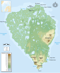
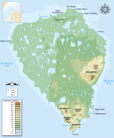
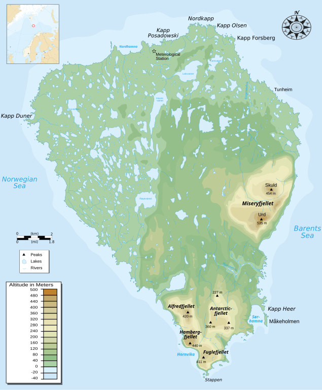
English: Topographic map of Bjørnøya island (Norway). |
| Date | |
| Source | Translated from Image:Bjørnøya map-fr.svg |
| Author | Pinpin |
| Other versions |
[]
|


|
This SVG file contains embedded text that can be translated into your language, using any capable SVG editor, text editor or the SVG Translate tool. For more information see: About translating SVG files. |
Licensing
I, the copyright holder of this work, hereby publish it under the following licenses:

|
Permission is granted to copy, distribute and/or modify this document under the terms of the GNU Free Documentation License, Version 1.2 or any later version published by the Free Software Foundation; with no Invariant Sections, no Front-Cover Texts, and no Back-Cover Texts. A copy of the license is included in the section entitled GNU Free Documentation License. |
This file is licensed under the Creative Commons Attribution-Share Alike 3.0 Unported, 2.5 Generic, 2.0 Generic and 1.0 Generic license.
- You are free:
- to share – to copy, distribute and transmit the work
- to remix – to adapt the work
- Under the following conditions:
- attribution – You must give appropriate credit, provide a link to the license, and indicate if changes were made. You may do so in any reasonable manner, but not in any way that suggests the licensor endorses you or your use.
- share alike – If you remix, transform, or build upon the material, you must distribute your contributions under the same or compatible license as the original.
You may select the license of your choice.
File history
Click on a date/time to view the file as it appeared at that time.
| Date/Time | Thumbnail | Dimensions | User | Comment | |
|---|---|---|---|---|---|
| current | 19:35, 15 May 2008 | | 2,195 × 2,653 (1.73 MB) | Bibi Saint-Pol | {{Inkscape}} == {{int:filedesc}} == {{Information |Description= {{en|Topographic map of Bjørnøya island (Norway).}} |Source=Translated from Image:Bjørnøya map-fr.svg |Date=2007-12-21 |Author= Pinpin |Permission= |other_versions={{ |
File usage
The following pages on the English Wikipedia use this file (pages on other projects are not listed):
Global file usage
The following other wikis use this file:
- Usage on ar.wiki.x.io
- Usage on az.wiki.x.io
- Usage on cs.wiki.x.io
- Usage on da.wiki.x.io
- Usage on el.wiki.x.io
- Usage on es.wiki.x.io
- Usage on fi.wiki.x.io
- Usage on gl.wiki.x.io
- Usage on hr.wiki.x.io
- Usage on hu.wiki.x.io
- Usage on lt.wiki.x.io
- Usage on ru.wiki.x.io
- Usage on sk.wiki.x.io
- Usage on sl.wiki.x.io
- Usage on sr.wiki.x.io
- Usage on sw.wiki.x.io
- Usage on uk.wiki.x.io
- Usage on vi.wiki.x.io