No higher resolution available.
Belize_topo.png (232 × 312 pixels, file size: 39 KB, MIME type: image/png)
| This is a file from the Wikimedia Commons. Information from its description page there is shown below. Commons is a freely licensed media file repository. You can help. |
Summary
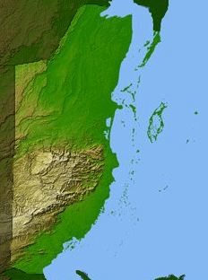
| Description | Shaded relief image of Belize created from Shuttle Radar Topography Mission (SRTM) data by NASA |
| Source | http://edc.usgs.gov/products/elevation.html (archived link at https://web.archive.org/web/20070427030404/http://edc.usgs.gov/products/elevation.html) |
| Author | NASA |
Seamless SRTM "Finished" 3 arc second (90 meter posting) digital raster elevation data.
Licensing
| This file is in the public domain in the United States because it was solely created by NASA. NASA copyright policy states that "NASA material is not protected by copyright unless noted". (See Template:PD-USGov, NASA copyright policy page or JPL Image Use Policy.) | ||
 |
Warnings:
|
File history
Click on a date/time to view the file as it appeared at that time.
| Date/Time | Thumbnail | Dimensions | User | Comment | |
|---|---|---|---|---|---|
| current | 17:18, 3 May 2007 | | 232 × 312 (39 KB) | Feydey | {{Information |Description=Shaded relief image of Belize created from Shuttle Radar Topography Mission (SRTM) data by NASA |Source=http://edc.usgs.gov/products/elevation.html |Date= |Author=NASA |Permission= |other_versions= }} Seamless SRTM "Finishe |
File usage
The following pages on the English Wikipedia use this file (pages on other projects are not listed):
Global file usage
The following other wikis use this file:
- Usage on cs.wiki.x.io
- Usage on es.wiki.x.io
- Usage on hr.wiki.x.io
- Usage on it.wiki.x.io
- Usage on lfn.wiki.x.io
- Usage on lt.wiki.x.io
- Usage on nds.wiki.x.io
- Usage on sl.wiki.x.io
- Usage on tl.wiki.x.io
- Usage on uk.wiki.x.io
- Usage on zh.wiki.x.io