No higher resolution available.
Beaver_Historic_District_map.png (720 × 588 pixels, file size: 261 KB, MIME type: image/png)
| This is a file from the Wikimedia Commons. Information from its description page there is shown below. Commons is a freely licensed media file repository. You can help. |
| Description |
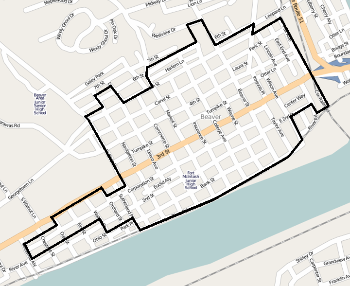
English: Map showing the boundaries of the Beaver Historic District in Beaver, Pennsylvania, United States. The historic district is listed on the National Register of Historic Places. Boundaries are derived from the map attached to the district's National Register nomination form. |
| Date | |
| Source | Screenshot of OpenStreetMap's map of the Beaver vicinity, with district boundary lines drawn by uploader |
| Author | OpenStreetMap editors (map), Nyttend (district boundaries) |
| Permission (Reusing this file) |
My work is public domain, and the original map is This file is licensed under the Creative Commons Attribution 2.0 Generic license.
|
File history
Click on a date/time to view the file as it appeared at that time.
| Date/Time | Thumbnail | Dimensions | User | Comment | |
|---|---|---|---|---|---|
| current | 23:18, 24 July 2009 | | 720 × 588 (261 KB) | Nyttend | {{Information |Description={{en|Map showing the boundaries of the {{w|Beaver Historic District}} in {{w|Beaver, Pennsylvania|Beaver}}, {{w|Pennsylvania}}, {{w|United States}}. The {{w|historic district (United States)|historic district}} is listed on the |
File usage
The following pages on the English Wikipedia use this file (pages on other projects are not listed):
Global file usage
The following other wikis use this file:
- Usage on bh.wiki.x.io
- Usage on bn.wiki.x.io
- Usage on fa.wiki.x.io
- Usage on fo.wiki.x.io
- Usage on hi.wiki.x.io
- Usage on km.wiki.x.io
- Usage on kn.wiki.x.io
- Usage on ml.wiki.x.io
- Usage on simple.wiki.x.io
- Usage on sl.wiki.x.io
- Usage on test.wiki.x.io
- Usage on te.wiki.x.io
- Usage on tum.wiki.x.io
- Usage on www.wikidata.org