Size of this preview: 800 × 532 pixels. Other resolutions: 320 × 213 pixels | 640 × 426 pixels | 1,024 × 681 pixels | 1,280 × 851 pixels | 2,560 × 1,702 pixels | 6,016 × 4,000 pixels.
Original file (6,016 × 4,000 pixels, file size: 5.27 MB, MIME type: image/jpeg)
| This is a file from the Wikimedia Commons. Information from its description page there is shown below. Commons is a freely licensed media file repository. You can help. |
Summary
| DescriptionBanská Bystrica 28.jpg |
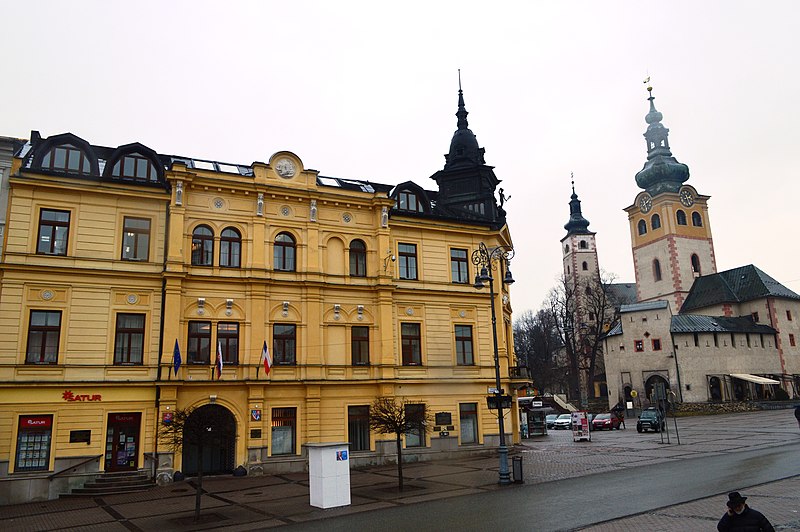
English: Banská Bystrica is a city in central w:en:Slovakia:Slovakia located on the Hron River in a long and wide valley encircled by the mountain chains of the Low Tatras, the Veľká Fatra, and the Kremnica Mountains. The present town was founded by German settlers, however it was built upon a former Slavic settlement. It obtained the municipal privileges of a free royal town of the Kingdom of Hungary in 1255. The copper mining town acquired its present picturesque look in the Late Middle Ages when the prosperous burghers built its central churches, mansions, and fortifications. It is the sixth most populous municipality in Slovakia and the capital of the ‘kraj’ (Banská Bystrica Region) and the ‘okres’ (Banská Bystrica District). It is also the home of Matej Bel University. As a historical city with an easy access to the surrounding mountains, Banská Bystrica is a popular winter and summer tourist destination. The Scotch Mist Gallery contains many photographs of historic buildings, monuments and memorials of Poland and beyond. |
| Date | |
| Source | Own work |
| Author | Scotch Mist |
| Camera location | 48° 44′ 06.03″ N, 19° 08′ 40.15″ E | View this and other nearby images on: OpenStreetMap |
|---|
Licensing
I, the copyright holder of this work, hereby publish it under the following license:
This file is licensed under the Creative Commons Attribution-Share Alike 4.0 International license.
- You are free:
- to share – to copy, distribute and transmit the work
- to remix – to adapt the work
- Under the following conditions:
- attribution – You must give appropriate credit, provide a link to the license, and indicate if changes were made. You may do so in any reasonable manner, but not in any way that suggests the licensor endorses you or your use.
- share alike – If you remix, transform, or build upon the material, you must distribute your contributions under the same or compatible license as the original.
Captions
Add a one-line explanation of what this file represents
Items portrayed in this file
depicts
1 March 2019
48°44'6.029"N, 19°8'40.146"E
0.005 second
10
18 millimetre
400
image/jpeg
7b6baf333f725a113d513aa180b9a7d587b62b2b
5,522,900 byte
4,000 pixel
6,016 pixel
File history
Click on a date/time to view the file as it appeared at that time.
| Date/Time | Thumbnail | Dimensions | User | Comment | |
|---|---|---|---|---|---|
| current | 18:55, 12 May 2019 |  | 6,016 × 4,000 (5.27 MB) | Scotch Mist | User created page with UploadWizard |
File usage
The following page uses this file:
Metadata
This file contains additional information, probably added from the digital camera or scanner used to create or digitize it.
If the file has been modified from its original state, some details may not fully reflect the modified file.
| Camera manufacturer | NIKON CORPORATION |
|---|---|
| Camera model | NIKON D3200 |
| Exposure time | 1/200 sec (0.005) |
| F-number | f/10 |
| ISO speed rating | 400 |
| Date and time of data generation | 14:59, 1 March 2019 |
| Lens focal length | 18 mm |
| Orientation | Normal |
| Software used | Ver.1.00 |
| File change date and time | 14:59, 1 March 2019 |
| Y and C positioning | Co-sited |
| Exposure Program | Not defined |
| Exif version | 2.3 |
| Date and time of digitizing | 14:59, 1 March 2019 |
| Meaning of each component |
|
| Image compression mode | 2 |
| Exposure bias | 0 |
| Maximum land aperture | 3.6 APEX (f/3.48) |
| Metering mode | Pattern |
| Light source | Unknown |
| Flash | Flash did not fire, compulsory flash suppression |
| DateTime subseconds | 80 |
| DateTimeOriginal subseconds | 80 |
| DateTimeDigitized subseconds | 80 |
| Supported Flashpix version | 1 |
| Color space | sRGB |
| Sensing method | One-chip color area sensor |
| File source | Digital still camera |
| Scene type | A directly photographed image |
| Custom image processing | Normal process |
| Exposure mode | Auto exposure |
| White balance | Auto white balance |
| Digital zoom ratio | 1 |
| Focal length in 35 mm film | 27 mm |
| Scene capture type | Landscape |
| Scene control | Low gain up |
| Contrast | Normal |
| Saturation | Normal |
| Sharpness | Normal |
| Subject distance range | Unknown |
| GPS tag version | 2.3.0.0 |
Retrieved from "https://en.wiki.x.io/wiki/File:Banská_Bystrica_28.jpg"