No higher resolution available.
Amt_Vioel_in_NF.PNG (353 × 340 pixels, file size: 7 KB, MIME type: image/png)
| This is a file from the Wikimedia Commons. Information from its description page there is shown below. Commons is a freely licensed media file repository. You can help. |

|
Permission is granted to copy, distribute and/or modify this document under the terms of the GNU Free Documentation License, Version 1.2 or any later version published by the Free Software Foundation; with no Invariant Sections, no Front-Cover Texts, and no Back-Cover Texts. A copy of the license is included in the section entitled GNU Free Documentation License. |
| This file is licensed under the Creative Commons Attribution-Share Alike 3.0 Unported license. | ||
| ||
| This licensing tag was added to this file as part of the GFDL licensing update. |
Summary
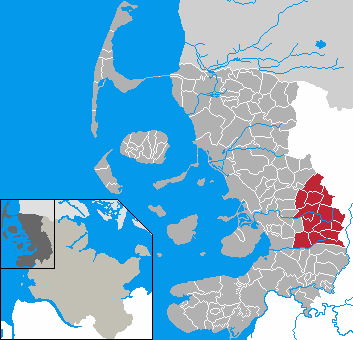
- en: This map shows the area of the Amt (group of municipalities) de:Amt Viöl in the Kreis (district) Nordfriesland, Schleswig-Holstein, Germany.
- de: Diese Karte zeigt das Gebiet des Amts Viöl im Kreis Nordfriesland, Schleswig-Holstein, Deutschland.
- en: The map was created by de:Benutzer:Rauenstein.
- de: Die Karte wurde von de:Benutzer:Rauenstein erstellt.
- en: Location marked by de:Benutzer:Begw.
- de: Position durch de:Benutzer:Begw markiert.
File history
Click on a date/time to view the file as it appeared at that time.
| Date/Time | Thumbnail | Dimensions | User | Comment | |
|---|---|---|---|---|---|
| current | 20:15, 21 January 2007 | | 353 × 340 (7 KB) | Ditschi | Corrections in Klanxbüll and Rodenäs, Reußenköge and Ockholm |
| 21:57, 9 January 2007 |  | 353 × 340 (7 KB) | Ditschi | ||
| 04:35, 5 February 2006 |  | 353 × 340 (7 KB) | Begw | {{GFDL}} == Beschreibung == * en: This map shows the area of the Amt (group of municipalities) de:Amt Viöl in the Kreis (district) Nordfriesland, Schleswig-Holstein, Germany. * de: Diese Karte zeigt das Gebiet des Amts Viöl im |
File usage
The following page uses this file:
Global file usage
The following other wikis use this file:
- Usage on ca.wiki.x.io
- Usage on ceb.wiki.x.io
- Usage on de.wiki.x.io
- Usage on eo.wiki.x.io
- Usage on frr.wiki.x.io
- Usage on fr.wiki.x.io
- Usage on it.wiki.x.io
- Usage on nl.wiki.x.io
- Usage on pl.wiki.x.io
- Usage on ru.wiki.x.io
- Usage on www.wikidata.org
- Usage on zh-min-nan.wiki.x.io