
Size of this preview: 638 × 600 pixels. Other resolutions: 255 × 240 pixels | 510 × 480 pixels | 817 × 768 pixels | 1,089 × 1,024 pixels | 2,112 × 1,986 pixels.
Original file (2,112 × 1,986 pixels, file size: 319 KB, MIME type: image/png)
| This is a file from the Wikimedia Commons. Information from its description page there is shown below. Commons is a freely licensed media file repository. You can help. |
Summary
| Description |
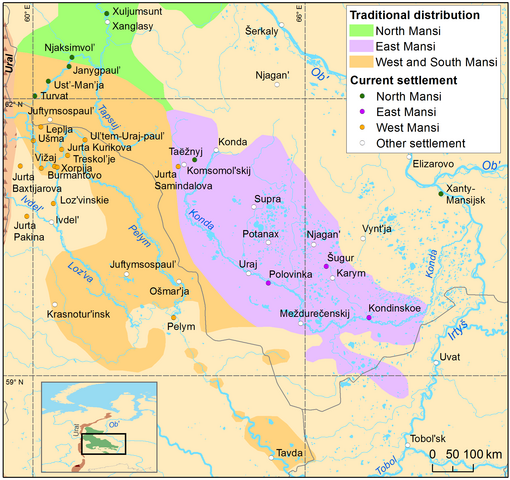
English: Distribution of East Mansi varieties in past and present |
| Date | |
| Source | https://sites.utu.fi/urhia/language-maps/ |
| Author |
Rantanen, T., Tolvanen, H., Roose, M., Ylikoski, J. & Vesakoski, O. (2022) “Best practices for spatial language data harmonization, sharing and map creation – A case study of Uralic” PLoS ONE 17(6): e0269648. https://doi.org/10.1371/journal.pone.0269648. Rantanen, Timo, Vesakoski, Outi, Ylikoski, Jussi, & Tolvanen, Harri. (2021). Geographical database of the Uralic languages (v1.0) [Data set]. Zenodo. https://doi.org/10.5281/zenodo.4784188 |
Licensing
This file is licensed under the Creative Commons Attribution 4.0 International license.
- You are free:
- to share – to copy, distribute and transmit the work
- to remix – to adapt the work
- Under the following conditions:
- attribution – You must give appropriate credit, provide a link to the license, and indicate if changes were made. You may do so in any reasonable manner, but not in any way that suggests the licensor endorses you or your use.
File history
Click on a date/time to view the file as it appeared at that time.
| Date/Time | Thumbnail | Dimensions | User | Comment | |
|---|---|---|---|---|---|
| current | 14:41, 27 January 2024 | | 2,112 × 1,986 (319 KB) | Jähmefyysikko | Uploaded a work by Rantanen, T., Tolvanen, H., Roose, M., Ylikoski, J. & Vesakoski, O. (2022) “Best practices for spatial language data harmonization, sharing and map creation – A case study of Uralic” PLoS ONE 17(6): e0269648. https://doi.org/10.1371/journal.pone.0269648. Rantanen, Timo, Vesakoski, Outi, Ylikoski, Jussi, & Tolvanen, Harri. (2021). Geographical database of the Uralic languages (v1.0) [Data set]. Zenodo. https://doi.org/10.5281/zenodo.4784188 from https://sites.utu.fi/urhia/l... |
File usage
The following pages on the English Wikipedia use this file (pages on other projects are not listed):