Size of this preview: 603 × 599 pixels. Other resolutions: 241 × 240 pixels | 483 × 480 pixels | 773 × 768 pixels | 1,030 × 1,024 pixels | 2,060 × 2,048 pixels | 5,613 × 5,580 pixels.
Original file (5,613 × 5,580 pixels, file size: 14.1 MB, MIME type: image/jpeg)
| This is a file from the Wikimedia Commons. Information from its description page there is shown below. Commons is a freely licensed media file repository. You can help. |
Summary
| Description |
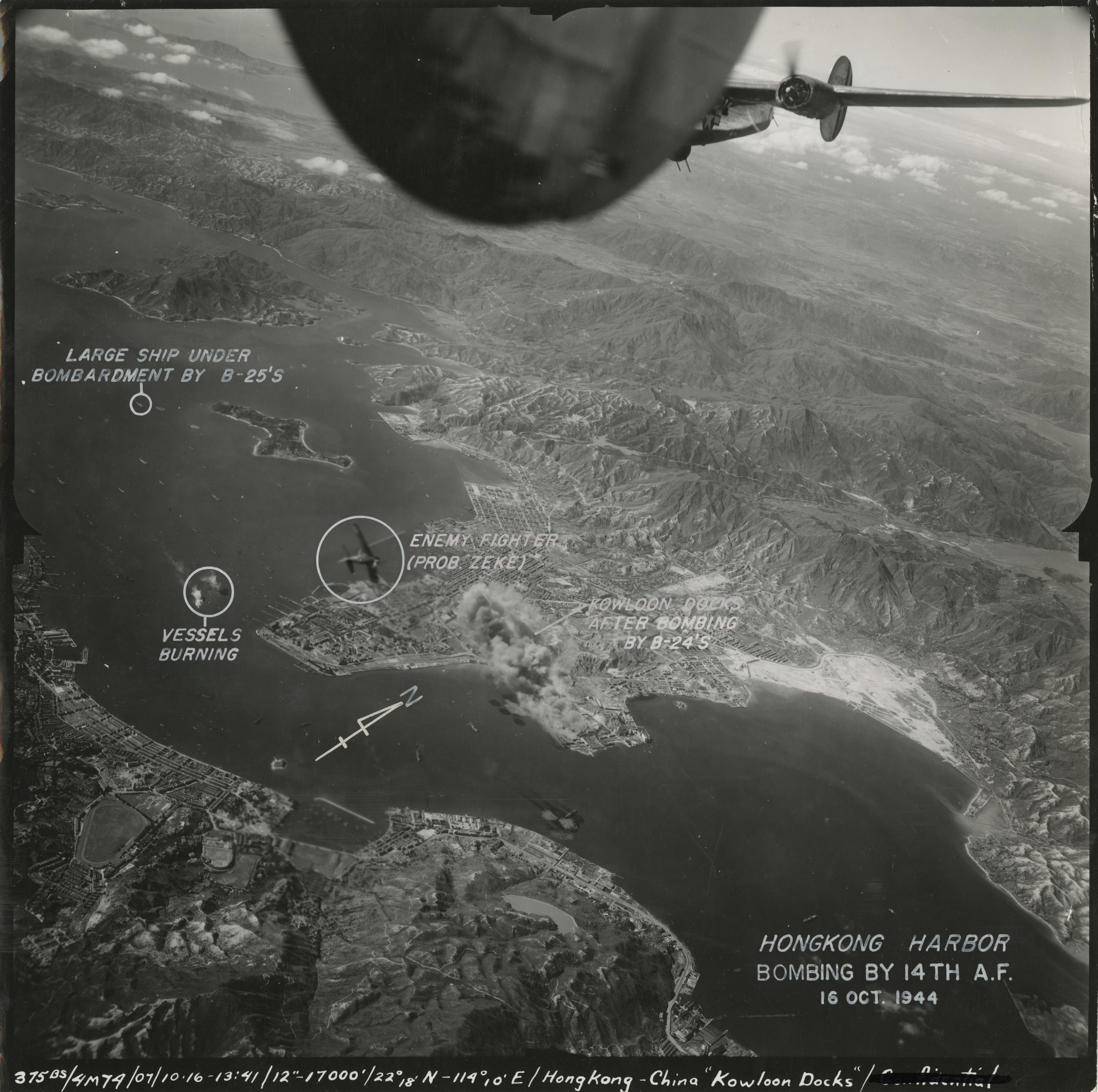
English: *Topic of this photo: Air raids on Hong Kong by the allied powers on 16 October 1944. At the center of this photo, Japanese-held Kowloon Docks is on fire. To the left of the fire, a Japanese plane, probably a Mitsubishi A6M Zero (Zeke), is fighting back. In this mission, the US Fourteenth Air Force sent out 28 B-24 heavy bombers, 33 P-51 fighter-bombers and 18 P-40 fighters to Japanese-occupied Hong Kong.[1] These planes most probably departed from Kweilin Airfield, 530 km (330 miles) northwest from Hong Kong. For the original photo wihthout annotated, see File:1944-10-16 US air raids on Japanese-occupied Hong Kong 1.jpg.
中文:*核心信息: 1944年10月16日盟軍空襲香港。在圖中央,着火冒煙的是日軍控制的黃埔船塢。火球左上方是正在反擊的日本軍機,很可能是零式艦上戰鬥機。此次任務,美國第十四航空隊遣28架B-24重型轟炸機、33架P-51戰鬥轟炸機和18架P-40戰鬥機到日佔香港。[1]這些戰機最有可能從桂林李家村機場起航,距日佔香港530公里。本照片的原圖(沒有文字說明)見 File:1944-10-16 US air raids on Japanese-occupied Hong Kong 1.jpg.
|
| Date | |
| Source | https://www.flickr.com/photos/fdrlibrary/7021430911/ |
| Author | FDR Presidential Library & Museum |
| Camera location | | View this and other nearby images on: OpenStreetMap |
|---|
Licensing
This file is licensed under the Creative Commons Attribution 2.0 Generic license.
- You are free:
- to share – to copy, distribute and transmit the work
- to remix – to adapt the work
- Under the following conditions:
- attribution – You must give appropriate credit, provide a link to the license, and indicate if changes were made. You may do so in any reasonable manner, but not in any way that suggests the licensor endorses you or your use.
| This image was originally posted to Flickr by FDR Presidential Library & Museum at https://flickr.com/photos/54078784@N08/7021430911. It was reviewed on 23 January 2021 by FlickreviewR 2 and was confirmed to be licensed under the terms of the cc-by-2.0. |
References
- ↑ a b (1991) U.S. Army Air Forces in World War II: Combat Chronology, Washington, D.C.: Center for Air Force History, p. 518
File history
Click on a date/time to view the file as it appeared at that time.
| Date/Time | Thumbnail | Dimensions | User | Comment | |
|---|---|---|---|---|---|
| current | 10:15, 23 January 2021 | | 5,613 × 5,580 (14.1 MB) | Lovewhatyoudo | Uploaded a work by FDR Presidential Library & Museum from https://www.flickr.com/photos/fdrlibrary/7021430911/ with UploadWizard |
File usage
The following page uses this file: