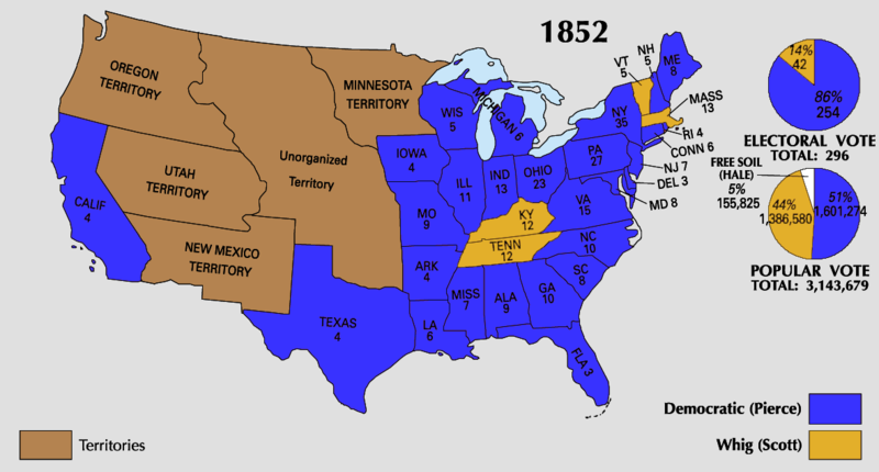
File:1852 Electoral Map.png

Original file(1,182 × 635 pixels, file size: 51 KB, MIME type: image/png)

U.S. presidential election maps
from the National Atlas of the United States
See also: SVG maps
1789 · 1792 · 1796 · 1800 · 1804 · 1808 · 1812 · 1816 · 1820 · 1824 · 1828 · 1832 · 1836 · 1840 · 1844 · 1848 · 1852 · 1856 · 1860 · 1864 · 1868 · 1872 · 1876 · 1880 · 1884 · 1888 · 1892 · 1896 · 1900 · 1904 · 1908 · 1912 · 1916 · 1920 · 1924 · 1928 · 1932 · 1936 · 1940 · 1944 · 1948 · 1952 · 1956 · 1960 · 1964 · 1968 · 1972 · 1976 · 1980 · 1984 · 1988 · 1992 · 1996 · 2000 · 2004

(this template: · view · discuss)


Summary

Description
Source https://nationalmap.gov/small_scale/printable/elections.html
Author United States Geological Survey
Other versions

Licensing

Public domain
This map was obtained from an edition of the National Atlas of the United States. Like almost all works of the U.S. federal government, works from the National Atlas are in the public domain in the United States.
Online access: NationalAtlas.gov | 1970 print edition: Library of Congress, Perry-Castañeda Library

čeština | Deutsch | English | français | Bahasa Indonesia | italiano | македонски | മലയാളം | sicilianu | 中文 | 中文(简体)‎ | 中文(繁體)‎ | +/−

Captions

Add a one-line explanation of what this file represents

Items portrayed in this file

depicts

image/png

3bdca1512f300db83185539a78da1a17216a3e62

52,554 byte

635 pixel

1,182 pixel

File history

Click on a date/time to view the file as it appeared at that time.

Date/TimeThumbnailDimensionsUserComment
current19:42, 30 April 2011Thumbnail for version as of 19:42, 30 April 20111,182 × 635 (51 KB)Hardwiggoptimized with http://www.pngoptimizer.com
23:25, 25 June 2008Thumbnail for version as of 23:25, 25 June 20081,182 × 635 (155 KB)Tallicfan20better quality
01:13, 27 May 2008Thumbnail for version as of 01:13, 27 May 20081,182 × 635 (141 KB)Tallicfan20
01:12, 27 May 2008Thumbnail for version as of 01:12, 27 May 20081,182 × 635 (142 KB)Tallicfan20
05:00, 17 May 2008Thumbnail for version as of 05:00, 17 May 20081,182 × 635 (90 KB)Tallicfan20{{PD-USGov-Atlas}}
No pages on the English Wikipedia use this file (pages on other projects are not listed).

Global file usage

The following other wikis use this file:

Metadata