File:1818 Pinkerton Map of Turkey in Asia, Iraq, Syria, and Palestine - Geographicus - TurkeyAsia-pinkerton-1818.jpg
Size of this preview: 800 × 586 pixels. Other resolutions: 320 × 235 pixels | 640 × 469 pixels | 1,024 × 751 pixels | 1,280 × 938 pixels | 2,560 × 1,876 pixels | 4,000 × 2,932 pixels.
Original file (4,000 × 2,932 pixels, file size: 2.67 MB, MIME type: image/jpeg)
| This is a file from the Wikimedia Commons. Information from its description page there is shown below. Commons is a freely licensed media file repository. You can help. |
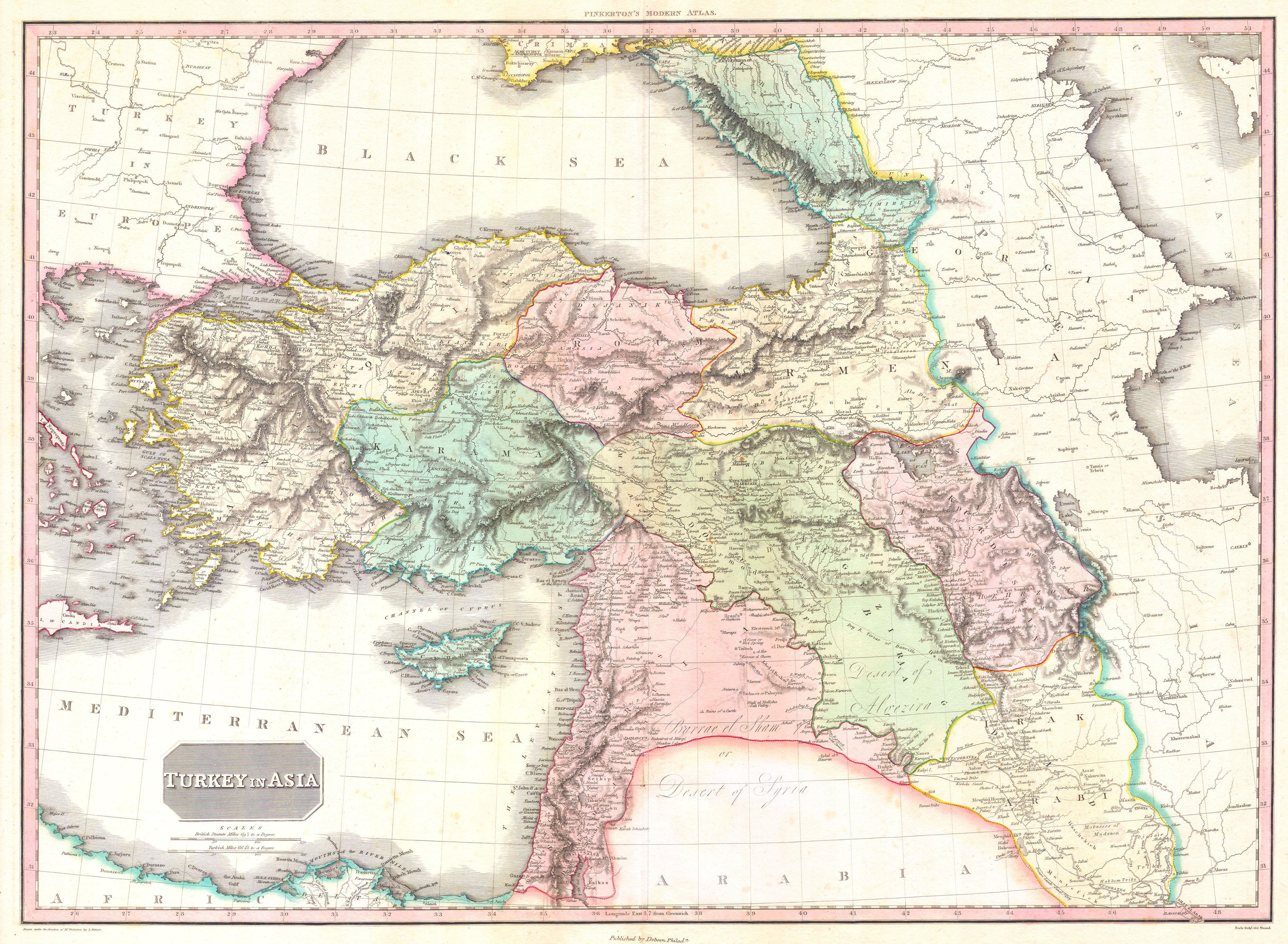
| John Pinkerton: Turkey in Asia.
( |
|||||||||||||||||||||
|---|---|---|---|---|---|---|---|---|---|---|---|---|---|---|---|---|---|---|---|---|---|
| Artist |
|
||||||||||||||||||||
| Title |
Turkey in Asia. |
||||||||||||||||||||
| Description |
English: This is John Pinkerton's stunning 1818 map of Turkey in Asia. Covers the holdings of the early 19th century Ottoman Empire in Asia, inclusive of modern day Turkey, Iraq, Cyprus, Syria, Jordan, Israel, Palestine, Lebanon, Georgia, Armenia, and Azerbaijan. Area of coverage extends from the Aegean Sea to the Caspian Sea and from the mouth of the Nile and the Dead Sea to the Crimea and the Black Sea. This beautifully rendered map is truly a masterpiece of engraving, with mountain ranges, lakes, deserts, and rivers excited with such precision that the result appears almost three dimensional. Pinkerton injects astounding detail throughout with countless towns, cities, geographical features, rivers, islands and bodies of water noted. Names numerous important sites are named, these include Mt. Ararat, the historic ruined Armenian capital of Ani, the ruined ancient Roman city of Palmyra, the ruins of several castles, etc. Drawn by L. Herbert and engraved by Samuel Neele under the direction of John Pinkerton. This map was issued in the scarce American edition of Pinkerton’s Modern Atlas, published by Thomas Dobson & Co. of Philadelphia in 1818. |
||||||||||||||||||||
| Date | 1818 (undated) | ||||||||||||||||||||
| Dimensions | height: 21 in (53.3 cm); width: 28 in (71.1 cm) | ||||||||||||||||||||
| Accession number |
Geographicus link: TurkeyAsia-pinkerton-1818 |
||||||||||||||||||||
| Source/Photographer |
Pinkerton, J., A Modern Atlas, from the Lates and Best Authorities, Exhibiting the Various Divisions of the World with its chief Empires, Kingdoms, and States; in Sixty Maps, carefully reduced from the Larges and Most Authentic Sources. 1818, Philadelphia, Thomas Dobson Edition.
|
||||||||||||||||||||
| Permission (Reusing this file) |
|
||||||||||||||||||||
| Other versions |
|
||||||||||||||||||||


File history
Click on a date/time to view the file as it appeared at that time.
| Date/Time | Thumbnail | Dimensions | User | Comment | |
|---|---|---|---|---|---|
| current | 22:50, 23 March 2011 | | 4,000 × 2,932 (2.67 MB) | BotMultichillT | {{subst:User:Multichill/Geographicus |link=http://www.geographicus.com/P/AntiqueMap/TurkeyAsia-pinkerton-1818 |product_name=1818 Pinkerton Map of Turkey in Asia, Iraq, Syria, and Palestine |map_title=Turkey in Asia. |description=This is John Pinkerton's |
File usage
The following pages on the English Wikipedia use this file (pages on other projects are not listed):
Global file usage
The following other wikis use this file:
- Usage on ba.wiki.x.io
- Usage on eo.wiki.x.io
- Usage on it.wiki.x.io
- Usage on pnb.wiki.x.io
- Usage on ru.wiki.x.io
- Usage on sl.wiki.x.io
- Usage on sr.wiki.x.io
- Usage on ur.wiki.x.io