
Size of this preview: 330 × 599 pixels. Other resolutions: 132 × 240 pixels | 400 × 726 pixels.
Original file (400 × 726 pixels, file size: 46 KB, MIME type: image/jpeg)
| This is a file from the Wikimedia Commons. Information from its description page there is shown below. Commons is a freely licensed media file repository. You can help. |
Summary
| Description |
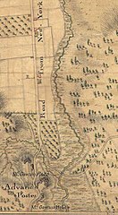
English: Detail of British military map of upper Manhattan (showing the approximate area from present-day 101st St to 118th St, west of Fifth Avenue). "A map of part of New-York Island showing a plan of Fort Washington, now call'd Ft. Kniphausen with the rebels lines on the south part, from which they were driven on the 16th of November 1776 by the troupes under the orders of the Earl of Percy. Survey'd the same day by order of His Lordship by C. J. Sauthier." |
|||||||||||||||||||||||||||||||||||||||||
| Date | ||||||||||||||||||||||||||||||||||||||||||
| Source |
|
|||||||||||||||||||||||||||||||||||||||||
| Author |
|
|||||||||||||||||||||||||||||||||||||||||

Licensing
This media file is in the public domain in the United States. This applies to U.S. works where the copyright has expired, often because its first publication occurred prior to January 1, 1929, and if not then due to lack of notice or renewal. See this page for further explanation.
|
 | |
 |
This image might not be in the public domain outside of the United States; this especially applies in the countries and areas that do not apply the rule of the shorter term for US works, such as Canada, Mainland China (not Hong Kong or Macao), Germany, Mexico, and Switzerland. The creator and year of publication are essential information and must be provided. See Wikipedia:Public domain and Wikipedia:Copyrights for more details.
|
Original upload log
Transferred from en.wikipedia to Commons using For the Common Good.
The original description page was here. All following user names refer to en.wikipedia.
| Date/Time | Dimensions | User | Comment |
|---|---|---|---|
| 19:47, 16 April 2011 | 400 × 726 (47,480 bytes) | w:en:Sallieparker (talk | contribs) | (Detail of British military map of upper Manhattan (showing the approximate area from present-day 101st St to 118th St, west of Fifth Avenue). "A map of part of New-York Island showing a plan of Fort Washington, now call'd Ft. Kniphausen with the rebels li) |
File history
Click on a date/time to view the file as it appeared at that time.
| Date/Time | Thumbnail | Dimensions | User | Comment | |
|---|---|---|---|---|---|
| current | 21:06, 19 December 2012 | | 400 × 726 (46 KB) | Delusion23 | Transferred from en.wikipedia: see original upload log above |
File usage
The following pages on the English Wikipedia use this file (pages on other projects are not listed):