.png)
.png&action=edit&redlink=1)
Size of this preview: 393 × 599 pixels. Other resolutions: 157 × 240 pixels | 315 × 480 pixels | 504 × 768 pixels | 1,165 × 1,775 pixels.
Original file (1,165 × 1,775 pixels, file size: 1.29 MB, MIME type: image/png)
| This is a file from the Wikimedia Commons. Information from its description page there is shown below. Commons is a freely licensed media file repository. You can help. |
.png)
Summary
| Description |
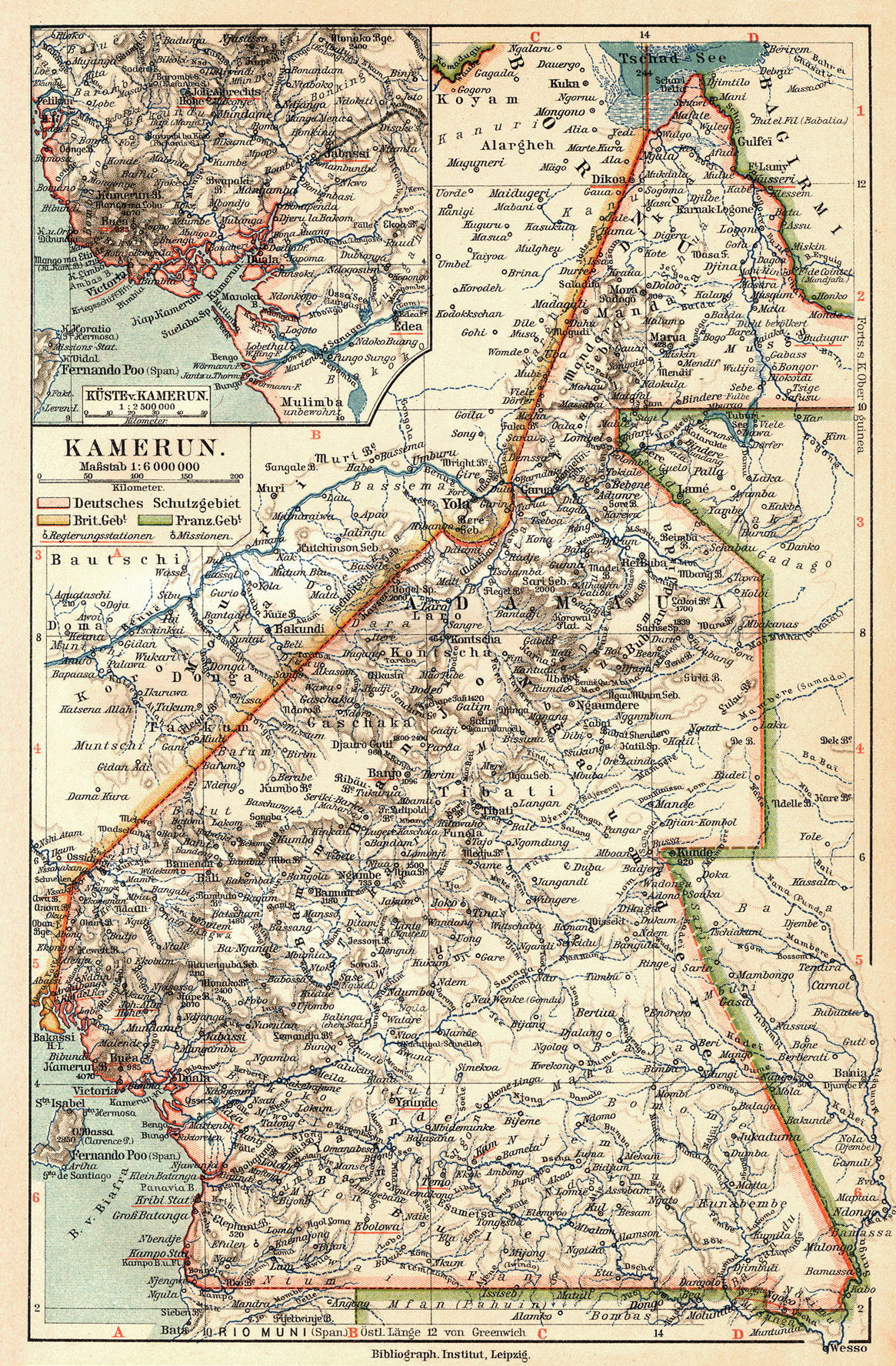
English: Cameroon (1905)
Deutsch: Kamerun (1905)
Slovenčina: Kamerun (1905) |
||||||||||||||||||||||
| Date | |||||||||||||||||||||||
| Source | Meyers Geographischer Hand-Atlas | ||||||||||||||||||||||
| Author |
|
||||||||||||||||||||||
Licensing
|
This is a faithful photographic reproduction of a two-dimensional, public domain work of art. The work of art itself is in the public domain for the following reason:
The official position taken by the Wikimedia Foundation is that "faithful reproductions of two-dimensional public domain works of art are public domain".
This photographic reproduction is therefore also considered to be in the public domain in the United States. In other jurisdictions, re-use of this content may be restricted; see Reuse of PD-Art photographs for details. | ||||
File history
Click on a date/time to view the file as it appeared at that time.
| Date/Time | Thumbnail | Dimensions | User | Comment | |
|---|---|---|---|---|---|
| current | 08:12, 25 July 2010 | | 1,165 × 1,775 (1.29 MB) | 14nu5 | {{Information |Description={{en|1=Cameroon (1905)}} {{de|1=Kamerun (1905)}} {{sk|1=Kamerun (1905)}} |Source=Meyers Geographischer Hand-Atlas |Author=Meyer, Hermann Julius (1826–1909); Bibliographisches Institut Leipzig |Date=1905 |Permission= |other_ver |
File usage
The following pages on the English Wikipedia use this file (pages on other projects are not listed):
Global file usage
The following other wikis use this file:
- Usage on be.wiki.x.io
- Usage on cs.wiki.x.io
- Usage on da.wiki.x.io
- Usage on de.wiki.x.io
- Usage on fi.wiki.x.io
- Usage on it.wiki.x.io
- Usage on pl.wiki.x.io
- Usage on sv.wiki.x.io
- Usage on uk.wiki.x.io
.png)