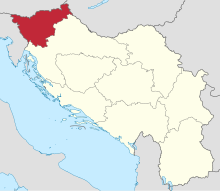
The Drava Banovina or Drava Banate (Slovene and Serbo-Croatian: Dravska banovina), was a province (banovina) of the Kingdom of Yugoslavia between 1929 and 1941. This province consisted of most of present-day Slovenia and was named for the Drava River. The capital city of the Drava Banovina was Ljubljana.
| Drava Banovina Dravska banovina Дравска бановина | |||||||||||||
|---|---|---|---|---|---|---|---|---|---|---|---|---|---|
| Banovina of the Kingdom of Yugoslavia | |||||||||||||
| 1929–1941 | |||||||||||||
 Drava Banovina (red) within Kingdom of Yugoslavia (light yellow) | |||||||||||||
| Capital | Ljubljana | ||||||||||||
| Area | |||||||||||||
• 1931 | 15,849 km2 (6,119 sq mi) | ||||||||||||
| Population | |||||||||||||
• 1921 | 1,060,356 | ||||||||||||
• 1931 | 1,144,298 | ||||||||||||
| Government | |||||||||||||
| • Type | Devolved autonomous banate | ||||||||||||
| Monarch | |||||||||||||
• 1929–1934 | Alexander I | ||||||||||||
• 1934–1941 | Peter II | ||||||||||||
| Ban | |||||||||||||
• 1929–1930 | Dušan Sernec | ||||||||||||
• 1935–1941 | Marko Natlačen | ||||||||||||
| Historical era | Interwar period | ||||||||||||
• Established | 3 October 1929 | ||||||||||||
| 3 September 1931 | |||||||||||||
| 16 April 1941 | |||||||||||||
| |||||||||||||
| Today part of | Slovenia, Croatia | ||||||||||||
Borders
editAccording to the 1931 Constitution of the Kingdom of Yugoslavia,
The Drava Banovina is bounded by a line passing from the point where the northern boundary of the district of Čabar cuts the State frontier, then following the State frontier with Italy, Austria and Hungary to a point where the State frontier with Hungary reaches the river Mura (north-east of Čakovec). From the river Mura, the boundary of the Banovina follows the eastern and then the southern boundaries; of the districts of Lendava, Ljutomer, Ptuj, Šmarje, Brežice, Krško, Novo Mesto, Metlika, Črnomelj, Kočevje and Logatec, including all the districts mentioned.[1]
Also in 1931, the Municipality of Štrigova (now in Croatia) was separated from the Čakovec District and the rest of Međimurje and was included in the Ljutomer District in the Drava Banovina.[2]
Administration
editThe Drava Banovina was administratively subdivided into 29 counties (called srez):
- Brežice
- Celje
- Celje (town)
- Črnomelj
- Dolnja Lendava
- Dravograd
- Gornji Grad
- Kamnik
- Kočevje
- Konjice
- Kranj
- Krško
- Laško
- Litija
- Logatec
- Ljubljana
- Ljubljana (town)
- Ljutomer
- Maribor, desni breg
- Maribor, levi breg
- Maribor (town)
- Metlika
- Murska Sobota
- Novo Mesto
- Ptuj
- Ptuj (town)
- Radovljica
- Slovenj Gradec
- Šmarje
Aftermath
editIn 1941 the World War II Axis powers occupied the Drava Banovina, and it was divided largely between Nazi Germany and Fascist Italy, while Hungary annexed Prekmurje and the Independent State of Croatia annexed some smaller border areas.[3]
Following World War II the region was reconstituted, with additional pre–World War II Italian territory (Julian March), as the Federal State of Slovenia, within a federal second Yugoslavia.
List of Bans
editThe following is the list of people who held the title of Ban (governor) of Drava Banovina:[4]
| Portrait | Name (Born-Died) |
Term of office | Party | ||
|---|---|---|---|---|---|
| Start | End | ||||
| Dušan Sernec (1882–1952) |
9 October 1929 |
4 December 1930 |
Slovene People's Party (SLS) | ||
| Drago Marušič (1884–1964) |
4 December 1930 |
8 February 1935 |
Yugoslav National Party (JNS) | ||
| Dinko Puc (1879–1945) |
8 February 1935 |
10 September 1935 |
Yugoslav Democratic Party (JDS) | ||
| Marko Natlačen (1886–1942) |
10 September 1935 |
16 April 1941 |
Slovene People's Party (SLS) | ||
See also
editReferences
edit- ^ The Constitution of the Kingdom of Yugoslavia
- ^ Kalšan, Vladimir (2006). Međimurska povijest [History of Međimurje] (in Croatian). Čakovec: Vladimir Kalšan. p. 285. ISBN 953-98293-1-3.
- ^ Možina, Jože (2019). Slovenski razkol. Celje: Društvo Mohorjeva družba. pp. 45ff. ISBN 978-961-278-468-3.
- ^ Cahoon, Ben. "Slovenia". World Statesmen.org. Retrieved 9 September 2013.
External links
editMedia related to Drava Banovina at Wikimedia Commons

