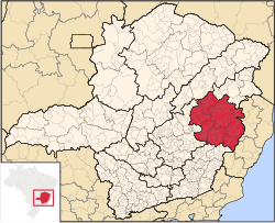
Vale do Rio Doce (English: Doce River valley) is one of the twelve mesoregions of the Brazilian state of Minas Gerais. It is composed of 102 municipalities,[1] distributed across 7 microregions.
Vale do Rio Doce | |
|---|---|
 Location within Minas Gerais | |
| Coordinates: 18°51′03″S 41°56′56″W / 18.85083°S 41.94889°W | |
| Country | |
| Region | Southeast |
| State | |
| Area | |
• Total | 41,809.873 km2 (16,142.882 sq mi) |
| Population (2006/IBGE) | |
• Total | 1,588,122 |
| Time zone | UTC-3 (BRT) |
| • Summer (DST) | UTC-2 (BRST) |
| Area code | +55 38 |
Demography
edit| Rank | Microregion | Pop. | Rank | Microregion | Pop. | ||||
|---|---|---|---|---|---|---|---|---|---|
| Governador Valadares Ipatinga |
1 | Governador Valadares | Governador Valadares | 263594 | 11 | Inhapim | Caratinga | 24294 | Coronel Fabriciano Caratinga |
| 2 | Ipatinga | Ipatinga | 239177 | 12 | Belo Oriente | Ipatinga | 23397 | ||
| 3 | Coronel Fabriciano | Ipatinga | 103797 | 13 | Itambacuri | Governador Valadares | 22797 | ||
| 4 | Caratinga | Caratinga | 85322 | 14 | Conselheiro Pena | Aimorés | 22232 | ||
| 5 | Timóteo | Ipatinga | 81119 | 15 | Ipanema | Aimorés | 18169 | ||
| 6 | Guanhães | Guanhães | 31266 | 16 | Peçanha | Peçanha | 17270 | ||
| 7 | Santana do Paraíso | Ipatinga | 27258 | 17 | Resplendor | Aimorés | 17099 | ||
| 8 | Mantena | Mantena | 27115 | 18 | Ipaba | Caratinga | 16692 | ||
| 9 | Mutum | Aimorés | 26672 | 19 | Sabinópolis | Guanhães | 15707 | ||
| 10 | Aimorés | Aimorés | 24969 | 20 | São João Evangelista | Guanhães | 15538 | ||
See also
editReferences
edit- ^ "Produto Interno Bruto dos Municípios" [GDP of the Brazilian Municipalities] (PDF) (in Portuguese). Brazilian Institute of Geography and Statistics (IBGE). 2010-11-01. Archived from the original (PDF) on 2014-04-24. Retrieved 2015-10-03.
- ^ "Censo 2010 - Minas Gerais" [2010 Census - Minas Gerais state] (PDF) (in Portuguese). Brazilian Institute of Geography and Statistics (IBGE). 2010-11-29. Retrieved 2011-06-11.