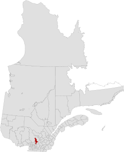
D'Autray (French pronunciation: [dotʁɛ]) is a regional county municipality in the Lanaudière region of Quebec, Canada. Its seat is Berthierville.
D'Autray | |
|---|---|
 | |
| Coordinates: 46°10′N 73°10′W / 46.167°N 73.167°W[1] | |
| Country | |
| Province | |
| Region | Lanaudière |
| Effective | January 1, 1982 |
| County seat | Berthierville |
| Government | |
| • Type | Prefecture |
| • Prefect | Gaétan Gravel |
| Area | |
• Total | 1,352.00 km2 (522.01 sq mi) |
| • Land | 1,249.30 km2 (482.36 sq mi) |
| Population (2016)[3] | |
• Total | 42,189 |
| • Density | 33.8/km2 (88/sq mi) |
| • Change 2011-2016 | |
| • Dwellings | 20,768 |
| Time zone | UTC−5 (EST) |
| • Summer (DST) | UTC−4 (EDT) |
| Area code(s) | 450 and 579 |
| Website | www |
The municipality has a land area of 1,249.30 km2 and its population was 42,189 inhabitants as of the 2016 Census.[3] Its largest community is the city of Lavaltrie.
Subdivisions
editThere are 15 subdivisions within the RCM:[2]
|
|
|
Demographics
editPopulation
editCanada census – D'Autray community profile
| 2021 | 2016 | 2011 | |
|---|---|---|---|
| Population | 44,080 (+4.5% from 2016) | 42,189 (+1.3% from 2011) | 41,650 (+3.3% from 2006) |
| Land area | 1,234.67 km2 (476.71 sq mi) | 1,249.3 km2 (482.4 sq mi) | 1,247.55 km2 (481.68 sq mi) |
| Population density | 35.7/km2 (92/sq mi) | 33.8/km2 (88/sq mi) | 33.4/km2 (87/sq mi) |
| Median age | 47.6 (M: 46.8, F: 48.0) | 47.0 (M: 46.4, F: 47.5) | 45.1 (M: 44.5, F: 45.6) |
| Private dwellings | 21,395 (total) 19,555 (occupied) | 20,768 (total) | 19,924 (total) |
| Median household income | $67,000 | $55,057 | $49,313 |
|
| |||||||||||||||||||||||||||
| [9][3] (A) adjusted figure due to boundary change. | ||||||||||||||||||||||||||||
Language
edit| Canada Census mother tongue - D'Autray Regional County Municipality, Quebec[9][3] | ||||||||||||||||||
|---|---|---|---|---|---|---|---|---|---|---|---|---|---|---|---|---|---|---|
| Census | Total | French
|
English
|
French & English
|
Other
| |||||||||||||
| Year | Responses | Count | Trend | Pop % | Count | Trend | Pop % | Count | Trend | Pop % | Count | Trend | Pop % | |||||
2016
|
41,705
|
40,525 | 0.9% | 97.2% | 415 | 2.4% | 1.0% | 175 | 5.4% | 0.4% | 590 | 45.7% | 1.4% | |||||
2011
|
41,190
|
40,175 | 4.1% | 97.5% | 425 | 12.4% | 1.0% | 185 | 131.2% | 0.5% | 405 | 36.2% | 1.0% | |||||
2006
|
39,800
|
38,600 | 5.6% | 96.98% | 485 | 2.0% | 1.22% | 80 | 56.8% | 0.20% | 635 | 81.4% | 1.60% | |||||
2001
|
37,585
|
36,555 | 1.0% | 97.26% | 495 | 76.8% | 1.32% | 185 | 37.0% | 0.49% | 350 | 62.8% | 0.93% | |||||
1996
|
36,840
|
36,210 | n/a | 98.29% | 280 | n/a | 0.76% | 135 | n/a | 0.37% | 215 | n/a | 0.58% | |||||
Transportation
editAccess routes
editHighways and numbered routes that run through the municipality, including external routes that start or finish at the county border:[10]
See also
editReferences
edit- ^ "Banque de noms de lieux du Québec: Reference number 141108". toponymie.gouv.qc.ca (in French). Commission de toponymie du Québec.
- ^ a b c "Répertoire des municipalités: Geographic code 520". www.mamh.gouv.qc.ca (in French). Ministère des Affaires municipales et de l'Habitation.
- ^ a b c d e "Census Profile, 2016 Census: D'Autray, Municipalité régionale de comté [Census division], Quebec". Statistics Canada. Retrieved November 27, 2019.
- ^ "2021 Community Profiles". 2021 Canadian census. Statistics Canada. February 4, 2022. Retrieved 2023-10-19.
- ^ "2016 Community Profiles". 2016 Canadian census. Statistics Canada. August 12, 2021. Retrieved 2019-11-27.
- ^ "2011 Community Profiles". 2011 Canadian census. Statistics Canada. March 21, 2019. Retrieved 2014-03-01.
- ^ "2006 Community Profiles". 2006 Canadian census. Statistics Canada. August 20, 2019.
- ^ "2001 Community Profiles". 2001 Canadian census. Statistics Canada. July 18, 2021.
- ^ a b Statistics Canada: 1996, 2001, 2006, 2011 census
- ^ Official Transport Quebec Road Map
External links
edit