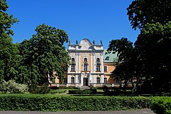
Czempiń [ˈt͡ʂɛmpʲiɲ] is a town in Kościan County, Greater Poland Voivodeship, Poland. As of December 2021, the town has a population of 4,921.[1]
Czempiń | |
|---|---|
 Ludwik Szołdrski Palace | |
| Coordinates: 52°9′42″N 16°46′38″E / 52.16167°N 16.77722°E | |
| Country | |
| Voivodeship | Greater Poland |
| County | Kościan |
| Gmina | Czempiń |
| Government | |
| • Mayor | Konrad Malicki |
| Area | |
| • Total | 3.29 km2 (1.27 sq mi) |
| Population (31 December 2021[1]) | |
| • Total | 4,921 |
| • Density | 1,500/km2 (3,900/sq mi) |
| Time zone | UTC+1 (CET) |
| • Summer (DST) | UTC+2 (CEST) |
| Postal code | 64-020 |
| Area code | +48 61 |
| Vehicle registration | PKS |
| Voivodeship roads | |
| Website | http://www.czempin.pl/ |
History
editAs part of the region of Greater Poland, i.e. the cradle of the Polish state, the area formed part of Poland since its establishment in the 10th century. It was a private town, administratively located in the Kościan County in the Poznań Voivodeship in the Greater Poland Province.[2] The Szołdrski family erected a Baroque palace in Czempiń.
During the German occupation of Poland (World War II), several prominent Poles from Czempiń were among the victims of massacres of Poles committed by the Germans in nearby Kościan on October 2 and 23, 1939 and in the forest near Kościan on November 7, 1939 (see also: Intelligenzaktion).[3] In 1939, 1941 and 1943, the occupiers carried out expulsions of Poles, whose houses were then handed over to German colonists as part of the Lebensraum policy.[4] Poles expelled in 1939 and 1943 were deported to the General Government in the more eastern part of German-occupied Poland, whereas expellees from 1941 were deported to forced labour in Germany.[4] Some local teachers were among Polish teachers murdered in the Mauthausen concentration camp.[5] In 1940, the Germans renamed the town to Karlshausen in attempt to erase traces of Polish origin.
Demographics
edit
|
| |||||||||||||||||||||||||||||||||||||||
| Source: [6][7][8] | ||||||||||||||||||||||||||||||||||||||||
Transport
editThe Voivodeship road 310 runs through Czempiń, and the S5 highway passes nearby, west of the town. There is a train station in Czempiń.
Sports
editThe local football club is Helios Czempiń. It competes in the lower leagues.
References
edit- ^ a b "Local Data Bank". Statistics Poland. Retrieved 2022-07-28. Data for territorial unit 3011024.
- ^ Atlas historyczny Polski. Wielkopolska w drugiej połowie XVI wieku. Część I. Mapy, plany (in Polish). Warszawa: Instytut Historii Polskiej Akademii Nauk. 2017. p. 1a.
- ^ Wardzyńska, Maria (2009). Był rok 1939. Operacja niemieckiej policji bezpieczeństwa w Polsce. Intelligenzaktion (in Polish). Warszawa: IPN. pp. 193, 198, 200.
- ^ a b Wardzyńska, Maria (2017). Wysiedlenia ludności polskiej z okupowanych ziem polskich włączonych do III Rzeszy w latach 1939-1945 (in Polish). Warszawa: IPN. pp. 157, 279, 280, 367. ISBN 978-83-8098-174-4.
- ^ Wardzyńska (2009), p. 214
- ^ Wiadomości Statystyczne Głównego Urzędu Statystycznego (in Polish). Vol. X. Warszawa: Główny Urząd Statystyczny. 1932. p. 201.
- ^ Dokumentacja Geograficzna (in Polish). Vol. 3/4. Warszawa: Instytut Geografii Polskiej Akademii Nauk. 1967. p. 8.
- ^ Stan i struktura ludności oraz ruch naturalny w przekroju terytorialnym w 2010 r. (PDF) (in Polish). Warszawa: Główny Urząd Statystyczny. 2011. p. 104. Archived from the original (PDF) on 13 November 2011.


