Blankenburg (German: [ˈblaŋkŋ̍ˌbʊʁk] ) is a German locality (Ortsteil) within the borough (Bezirk) of Pankow, Berlin. Until 2001 it was part of the former borough of Weißensee.
Blankenburg | |
|---|---|
 Aerial view with Französisch Buchholz (in north) | |
Location of Blankenburg in Pankow district and Berlin | |
 Blankenburg  Blankenburg | |
| Coordinates: 52°36′00″N 13°27′00″E / 52.60000°N 13.45000°E | |
| Country | Germany |
| State | Berlin |
| City | Berlin |
| Borough | Pankow |
| Founded | 1375 |
| Area | |
| • Total | 6.03 km2 (2.33 sq mi) |
| Elevation | 52 m (171 ft) |
| Population (2023-12-31)[1] | |
| • Total | 6,944 |
| • Density | 1,200/km2 (3,000/sq mi) |
| Time zone | UTC+01:00 (CET) |
| • Summer (DST) | UTC+02:00 (CEST) |
| Postal codes | 13129 |
| Vehicle registration | B |
| Website | Official website |
History
editThe locality, first mentioned in 1375,[2] was an autonomous municipality of the former Niederbarnim district, merged into Berlin in 1920 with the "Greater Berlin Act".[3]
Geography
editBlankenburg is located in the north-eastern suburb of Berlin and borders with the localities of Französisch Buchholz, Karow, Stadtrandsiedlung Malchow, Heinersdorf and, in a brief point, Pankow.
Transport
editThe locality is served by the Berlin S-Bahn lines S2, S8 and S9, at Blankenburg station, and by bus lines 150, 154 and 158. Blankenburger boundary with Französisch Buchholz is crossed by the motorway A114 and the nearest exit serving the locality is the n.4 ("Pasewalker Straße").
Personalities
edit- Johannes Maus (1916–1985), actor
Photogallery
edit-
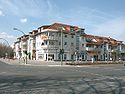
 Railway station
 -
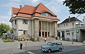
 Centre of the locality
 -
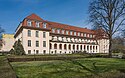 Rehabilitation center "Janus Korczak"
.jpg)


References
edit- ^ "Einwohnerinnen und Einwohner im Land Berlin am 31. Dezember 2023". Amt für Statistik Berlin-Brandenburg. February 2024.
- ^ (in German) History of Blankenburg
- ^ (in German) Text of the law and list of the former municipalities
External links
edit![]() Media related to Blankenburg at Wikimedia Commons
Media related to Blankenburg at Wikimedia Commons
- (in German) Blankenburg official website