You can help expand this article with text translated from the corresponding article in Portuguese. (June 2015) Click [show] for important translation instructions.
|
Arjona is a town and municipality located in the Bolívar Department, northern Colombia, about 30 km southeast of Cartagena de Indias.
Arjona | |
|---|---|
Municipality and town | |
| Nickname: La tierra del bollo de mazorca | |
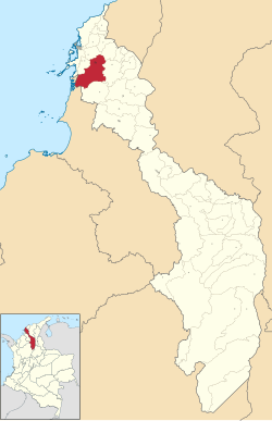
 Location of the municipality and town of Arjona in the Bolívar Department of Colombia | |
| Coordinates: 10°15′31″N 75°20′46″W / 10.25861°N 75.34611°W | |
| Country | |
| Department | |
| Founded | 1775 |
| Government | |
| • Mayor | Gustavo Perez |
| Area | |
• Municipality and town | 589.6 km2 (227.6 sq mi) |
| • Urban | 7.05 km2 (2.72 sq mi) |
| Elevation | 63 m (207 ft) |
| Population (2018 census)[1] | |
• Municipality and town | 69,503 |
| • Density | 120/km2 (310/sq mi) |
| • Urban | 55,134 |
| • Urban density | 7,800/km2 (20,000/sq mi) |
| Demonym | Arjonero |
| Area code | 57 + 5 |
| Website | Official website (in Spanish) |
Its primary activity is farming and producing the main recognized product, called Bollo by native people from there.
Notable people
edit- Ernesto Frieri, professional baseball player
- Ronaldo Hernández, professional baseball player
- José Quintana, professional baseball player
Climate
edit| Climate data for Arjona (Sincerin), elevation 10 m (33 ft), (1981–2010) | |||||||||||||
|---|---|---|---|---|---|---|---|---|---|---|---|---|---|
| Month | Jan | Feb | Mar | Apr | May | Jun | Jul | Aug | Sep | Oct | Nov | Dec | Year |
| Mean daily maximum °C (°F) | 34.0 (93.2) |
34.8 (94.6) |
34.9 (94.8) |
34.5 (94.1) |
32.9 (91.2) |
33.3 (91.9) |
33.1 (91.6) |
33.1 (91.6) |
32.5 (90.5) |
32.0 (89.6) |
31.8 (89.2) |
32.4 (90.3) |
33.2 (91.8) |
| Daily mean °C (°F) | 27.4 (81.3) |
27.7 (81.9) |
28.1 (82.6) |
28.2 (82.8) |
27.9 (82.2) |
28.0 (82.4) |
28.1 (82.6) |
27.7 (81.9) |
27.4 (81.3) |
27.2 (81.0) |
27.3 (81.1) |
27.3 (81.1) |
27.7 (81.9) |
| Mean daily minimum °C (°F) | 21.6 (70.9) |
22.0 (71.6) |
22.4 (72.3) |
23.8 (74.8) |
24.0 (75.2) |
24.1 (75.4) |
24.0 (75.2) |
23.8 (74.8) |
23.7 (74.7) |
23.5 (74.3) |
23.2 (73.8) |
22.4 (72.3) |
23.2 (73.8) |
| Average precipitation mm (inches) | 6.4 (0.25) |
18.0 (0.71) |
28.9 (1.14) |
89.9 (3.54) |
152.6 (6.01) |
128.1 (5.04) |
154.3 (6.07) |
161.5 (6.36) |
193.9 (7.63) |
195.3 (7.69) |
129.3 (5.09) |
49.2 (1.94) |
1,181.6 (46.52) |
| Average precipitation days (≥ 1.0 mm) | 1 | 2 | 3 | 7 | 12 | 11 | 11 | 13 | 13 | 15 | 11 | 5 | 95 |
| Average relative humidity (%) | 81 | 80 | 81 | 82 | 84 | 84 | 84 | 84 | 85 | 87 | 85 | 84 | 83 |
| Mean monthly sunshine hours | 257.3 | 223.0 | 201.5 | 168.0 | 158.1 | 168.0 | 189.1 | 189.1 | 141.0 | 142.6 | 165.0 | 223.2 | 2,225.9 |
| Mean daily sunshine hours | 8.3 | 7.9 | 6.5 | 5.6 | 5.1 | 5.6 | 6.1 | 6.1 | 4.7 | 4.6 | 5.5 | 7.2 | 6.1 |
| Source: Instituto de Hidrologia Meteorologia y Estudios Ambientales[2] | |||||||||||||
References
edit- ^ Citypopulation.de Population of Arjona municipality with localities
- ^ "Promedios Climatológicos 1981–2010" (in Spanish). Instituto de Hidrologia Meteorologia y Estudios Ambientales. Archived from the original on 15 August 2016. Retrieved 3 June 2024.


