This article needs additional citations for verification. (May 2009) |
Amakusa (天草市, Amakusa-shi) is a city located in Kumamoto Prefecture, Japan. As of 31 August 2024[update], the city had an estimated population of 72,243 in 36029 households, and a population density of 110 persons per km2.[1] The total area of the city is 683.82 km2 (264.02 sq mi).
Amakusa
天草市 | |
|---|---|
 Panorama view of Amakusa, from Jyunkyō Park | |
 Flag  Emblem | |
 Location of Amakusa in Kumamoto Prefecture | |
 | |
 Amakusa Location in Japan | |
| Coordinates: 32°27′31″N 130°11′35″E / 32.45861°N 130.19306°E | |
| Country | Japan |
| Region | Kyushu |
| Prefecture | Kumamoto |
| Government | |
| • Mayor | Shoji Baba |
| Area | |
| • Total | 683.82 km2 (264.02 sq mi) |
| Population (August 31, 2024) | |
| • Total | 72,243 |
| • Density | 110/km2 (270/sq mi) |
| Time zone | UTC+09:00 (JST) |
| City hall address | 8-1 Higashihamamachi, Amakusa-shi, Kumamoto-ken 863-0014 |
| Climate | Cfa |
| Website | Official website |
| Symbols | |
| Bird | Larus canus |
| Flower | Hibiscus hamabo |
| Tree | Ficus superba |
.jpg)


Geography
editAmakusa covers the majority of two main islands, Kamishima (上島, "Upper Island") and Shimoshima (下島, "Lower Island") (天草諸島), and six smaller inhabited islands and numerous uninhabited islets located the central-west Kumamoto Prefecture, in between the Yatsushiro Sea and the East China Sea. Large parts of the city are within the borders of the Unzen-Amakusa National Park.
Neighboring municipalities
editKumamoto Prefecture
Climate
editAmakusa has a humid subtropical climate (Köppen climate classification Cfa) with hot summers and cool winters. Precipitation is significant throughout the year, and is heaviest from May to August. The average annual temperature in Amakusa is 18.2 °C (64.8 °F). The average annual rainfall is 2,109.8 mm (83.06 in) with June as the wettest month. The temperatures are highest on average in August, at around 28.3 °C (82.9 °F), and lowest in January, at around 8.6 °C (47.5 °F).[2] The highest temperature ever recorded in Amakusa was 39.6 °C (103.3 °F) on 20 August 2013; the coldest temperature ever recorded was −7.0 °C (19.4 °F) on 25 January 2016.[3]
| Climate data for Ushibuka, Amakusa (1991−2020 normals, extremes 1949−present) | |||||||||||||
|---|---|---|---|---|---|---|---|---|---|---|---|---|---|
| Month | Jan | Feb | Mar | Apr | May | Jun | Jul | Aug | Sep | Oct | Nov | Dec | Year |
| Record high °C (°F) | 21.8 (71.2) |
23.6 (74.5) |
24.5 (76.1) |
29.2 (84.6) |
31.2 (88.2) |
33.9 (93.0) |
37.5 (99.5) |
39.6 (103.3) |
37.1 (98.8) |
34.0 (93.2) |
27.8 (82.0) |
24.0 (75.2) |
39.6 (103.3) |
| Mean daily maximum °C (°F) | 11.8 (53.2) |
13.0 (55.4) |
16.1 (61.0) |
20.3 (68.5) |
24.2 (75.6) |
26.5 (79.7) |
30.4 (86.7) |
32.2 (90.0) |
29.6 (85.3) |
25.0 (77.0) |
19.6 (67.3) |
14.2 (57.6) |
21.9 (71.4) |
| Daily mean °C (°F) | 8.6 (47.5) |
9.4 (48.9) |
12.2 (54.0) |
16.3 (61.3) |
20.1 (68.2) |
23.1 (73.6) |
27.0 (80.6) |
28.3 (82.9) |
25.6 (78.1) |
21.1 (70.0) |
16.0 (60.8) |
10.8 (51.4) |
18.2 (64.8) |
| Mean daily minimum °C (°F) | 5.5 (41.9) |
6.0 (42.8) |
8.6 (47.5) |
12.6 (54.7) |
16.6 (61.9) |
20.5 (68.9) |
24.3 (75.7) |
25.4 (77.7) |
22.7 (72.9) |
17.8 (64.0) |
12.8 (55.0) |
7.6 (45.7) |
15.0 (59.1) |
| Record low °C (°F) | −3.0 (26.6) |
−3.4 (25.9) |
−1.6 (29.1) |
2.0 (35.6) |
9.4 (48.9) |
12.6 (54.7) |
18.0 (64.4) |
18.8 (65.8) |
14.1 (57.4) |
7.4 (45.3) |
2.8 (37.0) |
−1.5 (29.3) |
−3.4 (25.9) |
| Average precipitation mm (inches) | 79.7 (3.14) |
95.4 (3.76) |
124.7 (4.91) |
158.1 (6.22) |
178.7 (7.04) |
409.6 (16.13) |
348.9 (13.74) |
200.7 (7.90) |
204.0 (8.03) |
96.5 (3.80) |
106.5 (4.19) |
96.4 (3.80) |
2,109.8 (83.06) |
| Average snowfall cm (inches) | 1 (0.4) |
1 (0.4) |
0 (0) |
0 (0) |
0 (0) |
0 (0) |
0 (0) |
0 (0) |
0 (0) |
0 (0) |
0 (0) |
0 (0) |
1 (0.4) |
| Average precipitation days (≥ 1.0 mm) | 10.6 | 9.6 | 11.1 | 10.0 | 9.5 | 14.3 | 10.4 | 9.5 | 9.5 | 6.5 | 8.6 | 10.0 | 119.6 |
| Average snowy days (≥ 1 cm) | 0.3 | 0.4 | 0 | 0 | 0 | 0 | 0 | 0 | 0 | 0 | 0 | 0 | 0.7 |
| Average relative humidity (%) | 65 | 64 | 66 | 69 | 73 | 82 | 82 | 77 | 73 | 66 | 67 | 65 | 71 |
| Mean monthly sunshine hours | 105.4 | 121.7 | 160.9 | 180.9 | 189.7 | 124.1 | 193.1 | 227.9 | 192.0 | 191.0 | 147.2 | 118.4 | 1,954.5 |
| Source: Japan Meteorological Agency[3][2] | |||||||||||||
| Climate data for Hondo, Amakusa (1991−2020 normals, extremes 1977−present) | |||||||||||||
|---|---|---|---|---|---|---|---|---|---|---|---|---|---|
| Month | Jan | Feb | Mar | Apr | May | Jun | Jul | Aug | Sep | Oct | Nov | Dec | Year |
| Record high °C (°F) | 22.0 (71.6) |
23.2 (73.8) |
25.1 (77.2) |
29.5 (85.1) |
32.6 (90.7) |
35.2 (95.4) |
37.3 (99.1) |
37.6 (99.7) |
35.5 (95.9) |
33.3 (91.9) |
27.0 (80.6) |
25.1 (77.2) |
37.6 (99.7) |
| Mean daily maximum °C (°F) | 10.7 (51.3) |
12.2 (54.0) |
15.5 (59.9) |
20.7 (69.3) |
25.2 (77.4) |
27.3 (81.1) |
31.3 (88.3) |
32.5 (90.5) |
29.1 (84.4) |
24.0 (75.2) |
18.4 (65.1) |
12.9 (55.2) |
21.7 (71.0) |
| Daily mean °C (°F) | 6.2 (43.2) |
7.2 (45.0) |
10.3 (50.5) |
14.9 (58.8) |
19.2 (66.6) |
22.6 (72.7) |
26.5 (79.7) |
27.3 (81.1) |
24.0 (75.2) |
18.9 (66.0) |
13.4 (56.1) |
8.3 (46.9) |
16.6 (61.8) |
| Mean daily minimum °C (°F) | 2.1 (35.8) |
2.6 (36.7) |
5.3 (41.5) |
9.5 (49.1) |
14.0 (57.2) |
18.8 (65.8) |
22.9 (73.2) |
23.4 (74.1) |
20.2 (68.4) |
14.6 (58.3) |
9.1 (48.4) |
4.1 (39.4) |
12.2 (54.0) |
| Record low °C (°F) | −7.0 (19.4) |
−5.6 (21.9) |
−3.1 (26.4) |
0.4 (32.7) |
6.4 (43.5) |
10.9 (51.6) |
16.6 (61.9) |
17.5 (63.5) |
11.7 (53.1) |
3.4 (38.1) |
−0.2 (31.6) |
−3.2 (26.2) |
−7.0 (19.4) |
| Average precipitation mm (inches) | 83.1 (3.27) |
96.1 (3.78) |
132.6 (5.22) |
157.2 (6.19) |
169.9 (6.69) |
405.3 (15.96) |
340.5 (13.41) |
215.0 (8.46) |
195.4 (7.69) |
111.9 (4.41) |
108.4 (4.27) |
91.6 (3.61) |
2,106.3 (82.93) |
| Average precipitation days (≥ 1.0 mm) | 9.9 | 9.8 | 10.8 | 10.2 | 9.5 | 15.1 | 12.3 | 10.5 | 10.1 | 7.1 | 9.1 | 9.9 | 124.3 |
| Mean monthly sunshine hours | 108.8 | 126.6 | 163.1 | 183.7 | 190.7 | 119.2 | 178.2 | 216.0 | 179.8 | 184.3 | 142.4 | 120.9 | 1,915.7 |
| Source: Japan Meteorological Agency[4][5] | |||||||||||||
Demographics
editPer Japanese census data, the population of Amakusa in 2020 is 75,783 people.[6] Amakusa has been conducting censuses since 1920. Amakusa has the distinction of being the fastest depopulating city in Japan since the last census (2005).[citation needed]
|
| |||||||||||||||||||||||||||||||||||||||||||||||||||||||||||||||||||||
| Amakusa population statistics[6] | ||||||||||||||||||||||||||||||||||||||||||||||||||||||||||||||||||||||
History
editThe area of Amakusa was part of ancient Higo Province, During the Edo Period it was tenryō territory under direct control of the Tokugawa shogunate and administered from the office of the Nagasaki bugyō. After the Meiji restoration, the villages of Takahama, Fukurengi, Shimoda and Oe were established in Amakusa District, Kumamoto with the creation of the modern municipalities system on April 1, 1889. On September 21, 1956, these villages merged to form the town of Amakusa. The city of Amakusa was established on March 27, 2006, from a merger between the former cities of Hondo and Ushibuka, and the towns of Amakusa, Ariake, Goshoura, Itsuwa, Kawaura, Kuratake, Shinwa and Sumoto from Amakusa District.[citation needed]
Government
editAmakusa has a mayor-council form of government with a directly elected mayor and a unicameral city council of 26 members. Amakusa, together with the town of Reihoku contributes three members to the Kumamoto Prefectural Assembly. In terms of national politics, the city is part of the Kumamoto 4th district of the lower house of the Diet of Japan.
Economy
editAmakusa has a rural economy dominated by agriculture and commercial fishing. Tourism also plays a major role.
Amakusa Airlines is headquartered in Amakusa.[7]
Education
editAmakusa has 17 public elementary schools and 13 public junior high schools operated by the city government and four public high school operated by the Kumamoto Prefectural Board of Education. There is also one private high school. The prefecture also operates one school for the handicapped.
Transportation
editAirports
editRailways
editAmakusa has no passenger railway service. The nearest train station is Misumi Station on the JR Kyushu Misumi Line in Uki City.
Highways
editSister city relations
edit Encinitas, California, United States[8]
Local attractions
editSightseeing
edit- Alegria Gardens [citation needed]
- Amakusa Christian Museum
- Amakusa Dolphin Marine Land [citation needed]
- Ōe Catholic Church
- Sakitsu Church
- Shimoda Onsen hot springs
- Tanasoko Castle ruins, National Historic Site
- Unzen-Amakusa National Park
-
 Amakusa Christian Museum
 -
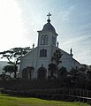 Ōe Catholic Church
 -
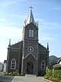 Sakitsu Catholic Church
 -
 Shimoda Onsen hot springs


Notable people from Amakusa
edit- Michiko Ishimure, writer
- Kundō Koyama, film writer
- Tochihikari Masayuki, sumo wrestler
- Kenta Matsumoto, vocalist and bassist of WANIMA
- Koushin Nishida, guitarist of WANIMA
- Hiroyuki Sonoda, statesman
- Sunao Sonoda, statesman
- Yoshiki Tanaka, novelist
References
edit- ^ "Amakusa City official statistics" (in Japanese). Japan.
- ^ a b 気象庁 / 平年値(年・月ごとの値). JMA. Retrieved February 27, 2022.
- ^ a b 観測史上1~10位の値(年間を通じての値). JMA. Retrieved February 27, 2022.
- ^ 観測史上1~10位の値(年間を通じての値). JMA. Retrieved April 16, 2022.
- ^ 気象庁 / 平年値(年・月ごとの値). JMA. Retrieved April 16, 2022.
- ^ a b Amakusa population statistics
- ^ "AMX会社概要 Archived 2009-08-04 at the Wayback Machine." Amakusa Airlines. Retrieved on May 20, 2009.
- ^ "City of Encinitas : Sister City Program". Archived from the original on 2012-07-14. Retrieved 2012-08-14.
External links
edit Media related to Amakusa, Kumamoto at Wikimedia Commons
- Amakusa City official website (in Japanese)
 Geographic data related to Amakusa, Kumamoto at OpenStreetMap